You are here: Home > Network List > CN - Canadian National Seismograph Network Stations List
> Station GAC GLEN ALMOND, QC > Earthquake Result Viewer
GAC GLEN ALMOND, QC - Earthquake Result Viewer
| Earthquake location: |
Kuril Islands |
| Earthquake latitude/longitude: |
51.0/157.4 |
| Earthquake time(UTC): |
2013/03/01 (060) 13:20:49 GMT |
| Earthquake Depth: |
29 km |
| Earthquake Magnitude: |
6.3 MB, 6.3 MS, 6.5 MW, 6.4 MW |
| Earthquake Catalog/Contributor: |
WHDF/NEIC |
|
| Network: |
CN Canadian National Seismograph Network |
| Station: |
GAC GLEN ALMOND, QC |
| Lat/Lon: |
45.70 N/75.48 W |
| Elevation: |
62 m |
|
| Distance: |
73.4 deg |
| Az: |
35.664 deg |
| Baz: |
328.252 deg |
| Ray Param: |
0.05296927 |
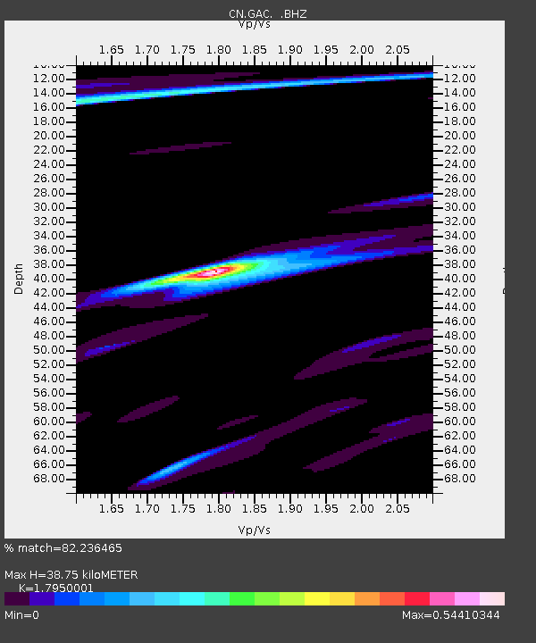
| Estimated Moho Depth: |
38.75 km |
| Estimated Crust Vp/Vs: |
1.80 |
| Assumed Crust Vp: |
6.419 km/s |
| Estimated Crust Vs: |
3.576 km/s |
| Estimated Crust Poisson's Ratio: |
0.27 |
|
| Radial Match: |
82.236465 % |
| Radial Bump: |
382 |
| Transverse Match: |
84.97426 % |
| Transverse Bump: |
400 |
| SOD ConfigId: |
494114 |
| Insert Time: |
2013-05-15 06:54:32.661 +0000 |
| GWidth: |
2.5 |
| Max Bumps: |
400 |
| Tol: |
0.001 |
|

Signal To Noise
| Channel | StoN | STA | LTA |
| CN:GAC: :BHZ:20130301T13:31:48.32502Z | 3.3150136 | 2.5119905E-6 | 7.5776177E-7 |
| CN:GAC: :BHN:20130301T13:31:48.32502Z | 1.6263 | 7.867934E-7 | 4.8379354E-7 |
| CN:GAC: :BHE:20130301T13:31:48.32502Z | 2.2820332 | 8.152062E-7 | 3.57228E-7 |
| Arrivals |
| Ps | 5.0 SECOND |
| PpPs | 16 SECOND |
| PsPs/PpSs | 21 SECOND |


