You are here: Home > Network List > CI - Caltech Regional Seismic Network Stations List
> Station SLA SLA, Trona, CA, USA > Earthquake Result Viewer
SLA SLA, Trona, CA, USA - Earthquake Result Viewer
| Earthquake location: |
Jujuy Province, Argentina |
| Earthquake latitude/longitude: |
-23.5/-66.5 |
| Earthquake time(UTC): |
2000/05/12 (133) 18:43:18 GMT |
| Earthquake Depth: |
225 km |
| Earthquake Magnitude: |
6.2 MB, 7.2 MW, 7.1 MW |
| Earthquake Catalog/Contributor: |
WHDF/NEIC |
|
| Network: |
CI Caltech Regional Seismic Network |
| Station: |
SLA SLA, Trona, CA, USA |
| Lat/Lon: |
35.89 N/117.28 W |
| Elevation: |
1174 m |
|
| Distance: |
76.2 deg |
| Az: |
319.587 deg |
| Baz: |
132.888 deg |
| Ray Param: |
0.05057227 |
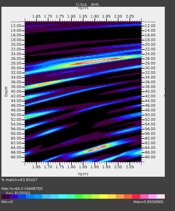
| Estimated Moho Depth: |
64.0 km |
| Estimated Crust Vp/Vs: |
1.91 |
| Assumed Crust Vp: |
6.276 km/s |
| Estimated Crust Vs: |
3.286 km/s |
| Estimated Crust Poisson's Ratio: |
0.31 |
|
| Radial Match: |
93.90407 % |
| Radial Bump: |
400 |
| Transverse Match: |
84.52634 % |
| Transverse Bump: |
400 |
| SOD ConfigId: |
3787 |
| Insert Time: |
2010-02-25 20:28:08.935 +0000 |
| GWidth: |
2.5 |
| Max Bumps: |
400 |
| Tol: |
0.001 |
|
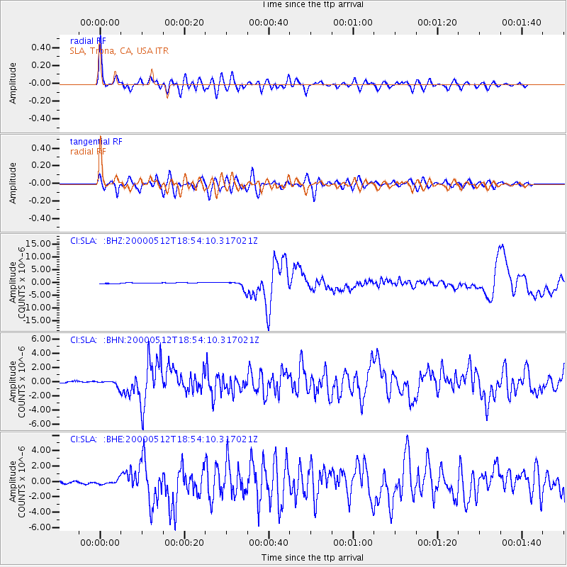
Signal To Noise
| Channel | StoN | STA | LTA |
| CI:SLA: :BHN:20000512T18:54:10.317021Z | 3.4999037 | 4.7436907E-7 | 1.3553775E-7 |
| CI:SLA: :BHE:20000512T18:54:10.317021Z | 1.5286976 | 3.214639E-7 | 2.1028613E-7 |
| CI:SLA: :BHZ:20000512T18:54:10.317021Z | 9.610725 | 1.6958624E-6 | 1.7645519E-7 |
| Arrivals |
| Ps | 9.5 SECOND |
| PpPs | 29 SECOND |
| PsPs/PpSs | 38 SECOND |


