You are here: Home > Network List > IW - Intermountain West Stations List
> Station SNOW Snow King Mountain, Wyoming, USA > Earthquake Result Viewer
SNOW Snow King Mountain, Wyoming, USA - Earthquake Result Viewer
| Earthquake location: |
Kuril Islands |
| Earthquake latitude/longitude: |
51.0/157.4 |
| Earthquake time(UTC): |
2013/03/01 (060) 13:20:49 GMT |
| Earthquake Depth: |
29 km |
| Earthquake Magnitude: |
6.3 MB, 6.3 MS, 6.5 MW, 6.4 MW |
| Earthquake Catalog/Contributor: |
WHDF/NEIC |
|
| Network: |
IW Intermountain West |
| Station: |
SNOW Snow King Mountain, Wyoming, USA |
| Lat/Lon: |
43.46 N/110.76 W |
| Elevation: |
2390 m |
|
| Distance: |
58.9 deg |
| Az: |
58.18 deg |
| Baz: |
312.435 deg |
| Ray Param: |
0.06248171 |
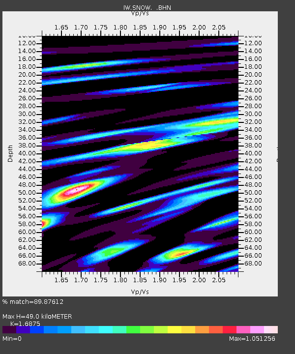
| Estimated Moho Depth: |
49.0 km |
| Estimated Crust Vp/Vs: |
1.69 |
| Assumed Crust Vp: |
6.207 km/s |
| Estimated Crust Vs: |
3.678 km/s |
| Estimated Crust Poisson's Ratio: |
0.23 |
|
| Radial Match: |
89.87612 % |
| Radial Bump: |
400 |
| Transverse Match: |
85.43172 % |
| Transverse Bump: |
400 |
| SOD ConfigId: |
494114 |
| Insert Time: |
2013-05-15 06:57:22.781 +0000 |
| GWidth: |
2.5 |
| Max Bumps: |
400 |
| Tol: |
0.001 |
|

Signal To Noise
| Channel | StoN | STA | LTA |
| IW:SNOW: :BHZ:20130301T13:30:15.515022Z | 18.63945 | 4.6084056E-6 | 2.4723937E-7 |
| IW:SNOW: :BHN:20130301T13:30:15.515022Z | 8.169211 | 2.8043214E-6 | 3.432793E-7 |
| IW:SNOW: :BHE:20130301T13:30:15.515022Z | 1.6755224 | 9.875596E-7 | 5.89404E-7 |
| Arrivals |
| Ps | 5.7 SECOND |
| PpPs | 20 SECOND |
| PsPs/PpSs | 26 SECOND |


