You are here: Home > Network List > TA - USArray Transportable Network (new EarthScope stations) Stations List
> Station POKR Poker Plat Research Range, AK, USA > Earthquake Result Viewer
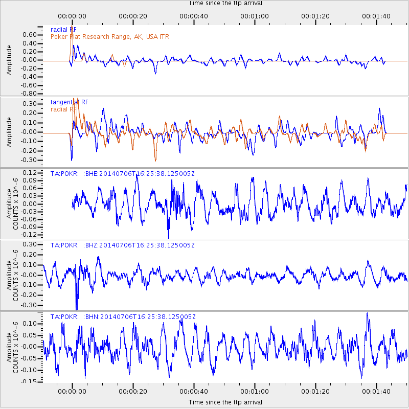
POKR Poker Plat Research Range, AK, USA - Earthquake Result Viewer
*The percent match for this event was below the threshold and hence no stack was calculated.
| Earthquake location: |
Northwest Of Kuril Islands |
| Earthquake latitude/longitude: |
47.7/147.5 |
| Earthquake time(UTC): |
2014/07/06 (187) 16:19:27 GMT |
| Earthquake Depth: |
399 km |
| Earthquake Magnitude: |
4.4 mb, 3.7 mb, 3.9 mb1, 3.8 mb1mx, 4.6 mbtmp |
| Earthquake Catalog/Contributor: |
ISC/ISC |
|
| Network: |
TA USArray Transportable Network (new EarthScope stations) |
| Station: |
POKR Poker Plat Research Range, AK, USA |
| Lat/Lon: |
65.12 N/147.43 W |
| Elevation: |
501 m |
|
| Distance: |
37.9 deg |
| Az: |
38.621 deg |
| Baz: |
275.098 deg |
| Ray Param: |
$rayparam |
*The percent match for this event was below the threshold and hence was not used in the summary stack. |
|
| Radial Match: |
47.931866 % |
| Radial Bump: |
400 |
| Transverse Match: |
67.73712 % |
| Transverse Bump: |
400 |
| SOD ConfigId: |
3390531 |
| Insert Time: |
2019-04-12 17:39:56.758 +0000 |
| GWidth: |
2.5 |
| Max Bumps: |
400 |
| Tol: |
0.001 |
|
Signal To Noise
| Channel | StoN | STA | LTA |
| TA:POKR: :BHZ:20140706T16:25:38.125005Z | 2.0193503 | 1.011474E-7 | 5.0089085E-8 |
| TA:POKR: :BHN:20140706T16:25:38.125005Z | 1.1993923 | 4.627267E-8 | 3.8580097E-8 |
| TA:POKR: :BHE:20140706T16:25:38.125005Z | 1.146641 | 4.6197986E-8 | 4.0289844E-8 |
| Arrivals |
| Ps | |
| PpPs | |
| PsPs/PpSs | |


