You are here: Home > Network List > NE - New England Seismic Network Stations List
> Station EMMW Machias, ME, USA > Earthquake Result Viewer
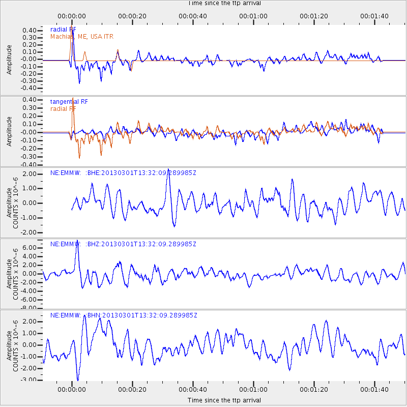
EMMW Machias, ME, USA - Earthquake Result Viewer
*The percent match for this event was below the threshold and hence no stack was calculated.
| Earthquake location: |
Kuril Islands |
| Earthquake latitude/longitude: |
51.0/157.4 |
| Earthquake time(UTC): |
2013/03/01 (060) 13:20:49 GMT |
| Earthquake Depth: |
29 km |
| Earthquake Magnitude: |
6.3 MB, 6.3 MS, 6.5 MW, 6.4 MW |
| Earthquake Catalog/Contributor: |
WHDF/NEIC |
|
| Network: |
NE New England Seismic Network |
| Station: |
EMMW Machias, ME, USA |
| Lat/Lon: |
44.71 N/67.46 W |
| Elevation: |
35 m |
|
| Distance: |
77.1 deg |
| Az: |
31.069 deg |
| Baz: |
332.76 deg |
| Ray Param: |
$rayparam |
*The percent match for this event was below the threshold and hence was not used in the summary stack. |
|
| Radial Match: |
73.59698 % |
| Radial Bump: |
400 |
| Transverse Match: |
47.97864 % |
| Transverse Bump: |
400 |
| SOD ConfigId: |
494114 |
| Insert Time: |
2013-05-15 07:01:09.748 +0000 |
| GWidth: |
2.5 |
| Max Bumps: |
400 |
| Tol: |
0.001 |
|
Signal To Noise
| Channel | StoN | STA | LTA |
| NE:EMMW: :BHZ:20130301T13:32:09.289985Z | 5.7422833 | 3.2305866E-6 | 5.625962E-7 |
| NE:EMMW: :BHN:20130301T13:32:09.289985Z | 2.0741022 | 1.6267146E-6 | 7.842982E-7 |
| NE:EMMW: :BHE:20130301T13:32:09.289985Z | 2.0524938 | 1.1307092E-6 | 5.5089527E-7 |
| Arrivals |
| Ps | |
| PpPs | |
| PsPs/PpSs | |


