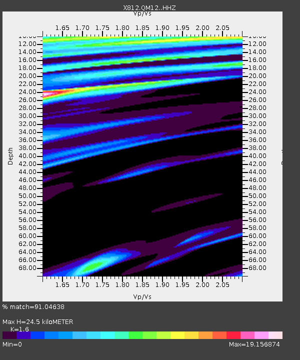
QM12 Camp Vic, Maine, USA - Earthquake Result Viewer

Earthquake location: Northwest Of Kuril Islands
Earthquake latitude/longitude: 47.7/147.5
Earthquake time(UTC): 2014/07/06 (187) 16:19:27 GMT
Earthquake Depth: 399 km
Earthquake Magnitude: 4.4 mb, 3.7 mb, 3.9 mb1, 3.8 mb1mx, 4.6 mbtmp
Earthquake Catalog/Contributor: ISC/ISC
Network: X8 Deep Structure of Three Continental Sutures in Eastern North America
Station: QM12 Camp Vic, Maine, USA
Lat/Lon: 44.97 N/67.86 W
Elevation: 15 m
Distance: 82.6 deg
Az: 24.443 deg
Baz: 336.822 deg
Ray Param: 0.045682956
Estimated Moho Depth: 24.5 km
Estimated Crust Vp/Vs: 1.60
Assumed Crust Vp: 6.419 km/s
Estimated Crust Vs: 4.012 km/s
Estimated Crust Poisson's Ratio: 0.18
Radial Match: 91.04638 %
Radial Bump: 361
Transverse Match: 94.877045 %
Transverse Bump: 257
SOD ConfigId: 3390531
Insert Time: 2019-04-12 17:41:20.639 +0000
GWidth: 2.5
Max Bumps: 400
Tol: 0.001

Signal To Noise

ChannelStoNSTALTA
X8:QM12: :HHZ:20140706T16:30:35.979985Z2.2532751.9343245E-68.584503E-7
X8:QM12: :HHN:20140706T16:30:35.979985Z2.21484268.843225E-53.992711E-5
X8:QM12: :HHE:20140706T16:30:35.979985Z2.84716273.4252324E-41.2030336E-4
Arrivals
Ps2.4 SECOND
PpPs9.7 SECOND
PsPs/PpSs12 SECOND