You are here: Home > Network List > TA - USArray Transportable Network (new EarthScope stations) Stations List
> Station G05D Wamic, OR, USA > Earthquake Result Viewer
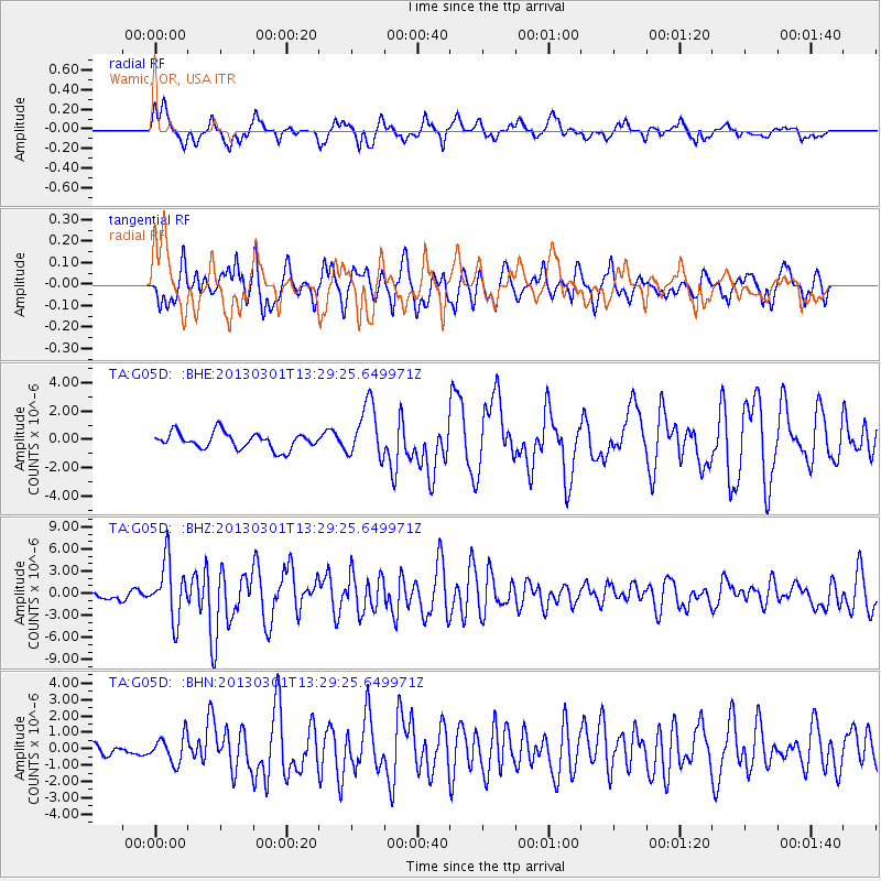
G05D Wamic, OR, USA - Earthquake Result Viewer
*The percent match for this event was below the threshold and hence no stack was calculated.
| Earthquake location: |
Kuril Islands |
| Earthquake latitude/longitude: |
51.0/157.4 |
| Earthquake time(UTC): |
2013/03/01 (060) 13:20:49 GMT |
| Earthquake Depth: |
29 km |
| Earthquake Magnitude: |
6.3 MB, 6.3 MS, 6.5 MW, 6.4 MW |
| Earthquake Catalog/Contributor: |
WHDF/NEIC |
|
| Network: |
TA USArray Transportable Network (new EarthScope stations) |
| Station: |
G05D Wamic, OR, USA |
| Lat/Lon: |
45.24 N/121.32 W |
| Elevation: |
592 m |
|
| Distance: |
52.0 deg |
| Az: |
62.432 deg |
| Baz: |
307.482 deg |
| Ray Param: |
$rayparam |
*The percent match for this event was below the threshold and hence was not used in the summary stack. |
|
| Radial Match: |
72.84107 % |
| Radial Bump: |
400 |
| Transverse Match: |
74.99885 % |
| Transverse Bump: |
400 |
| SOD ConfigId: |
494114 |
| Insert Time: |
2013-05-15 07:06:24.521 +0000 |
| GWidth: |
2.5 |
| Max Bumps: |
400 |
| Tol: |
0.001 |
|
Signal To Noise
| Channel | StoN | STA | LTA |
| TA:G05D: :BHZ:20130301T13:29:25.649971Z | 6.323139 | 3.8809985E-6 | 6.1377716E-7 |
| TA:G05D: :BHN:20130301T13:29:25.649971Z | 1.5333285 | 8.172934E-7 | 5.330191E-7 |
| TA:G05D: :BHE:20130301T13:29:25.649971Z | 3.276822 | 1.8917635E-6 | 5.7731654E-7 |
| Arrivals |
| Ps | |
| PpPs | |
| PsPs/PpSs | |


