You are here: Home > Network List > TA - USArray Transportable Network (new EarthScope stations) Stations List
> Station N02D Trinity Center, CA, USA > Earthquake Result Viewer
N02D Trinity Center, CA, USA - Earthquake Result Viewer
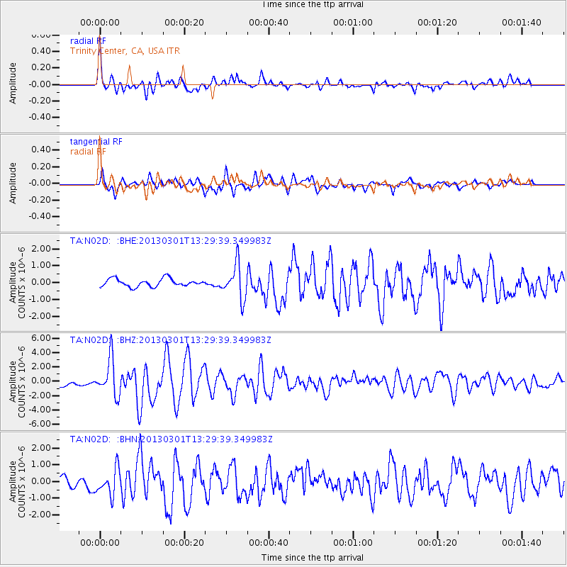
| Earthquake location: |
Kuril Islands |
| Earthquake latitude/longitude: |
51.0/157.4 |
| Earthquake time(UTC): |
2013/03/01 (060) 13:20:49 GMT |
| Earthquake Depth: |
29 km |
| Earthquake Magnitude: |
6.3 MB, 6.3 MS, 6.5 MW, 6.4 MW |
| Earthquake Catalog/Contributor: |
WHDF/NEIC |
|
| Network: |
TA USArray Transportable Network (new EarthScope stations) |
| Station: |
N02D Trinity Center, CA, USA |
| Lat/Lon: |
40.97 N/122.71 W |
| Elevation: |
937 m |
|
| Distance: |
53.8 deg |
| Az: |
67.411 deg |
| Baz: |
309.54 deg |
| Ray Param: |
0.06578051 |
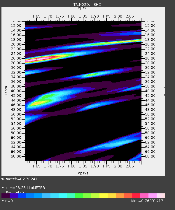
| Estimated Moho Depth: |
26.25 km |
| Estimated Crust Vp/Vs: |
1.65 |
| Assumed Crust Vp: |
6.566 km/s |
| Estimated Crust Vs: |
3.986 km/s |
| Estimated Crust Poisson's Ratio: |
0.21 |
|
| Radial Match: |
82.70241 % |
| Radial Bump: |
400 |
| Transverse Match: |
63.49373 % |
| Transverse Bump: |
400 |
| SOD ConfigId: |
494114 |
| Insert Time: |
2013-05-15 07:06:39.959 +0000 |
| GWidth: |
2.5 |
| Max Bumps: |
400 |
| Tol: |
0.001 |
|
Signal To Noise
| Channel | StoN | STA | LTA |
| TA:N02D: :BHZ:20130301T13:29:39.349983Z | 5.790534 | 2.6436787E-6 | 4.5655182E-7 |
| TA:N02D: :BHN:20130301T13:29:39.349983Z | 1.6190257 | 7.8885085E-7 | 4.87238E-7 |
| TA:N02D: :BHE:20130301T13:29:39.349983Z | 4.608917 | 1.0646704E-6 | 2.310023E-7 |
| Arrivals |
| Ps | 2.8 SECOND |
| PpPs | 10.0 SECOND |
| PsPs/PpSs | 13 SECOND |


