You are here: Home > Network List > TA - USArray Transportable Network (new EarthScope stations) Stations List
> Station M54A Oil Creek State Park, Oil City, PA, USA > Earthquake Result Viewer
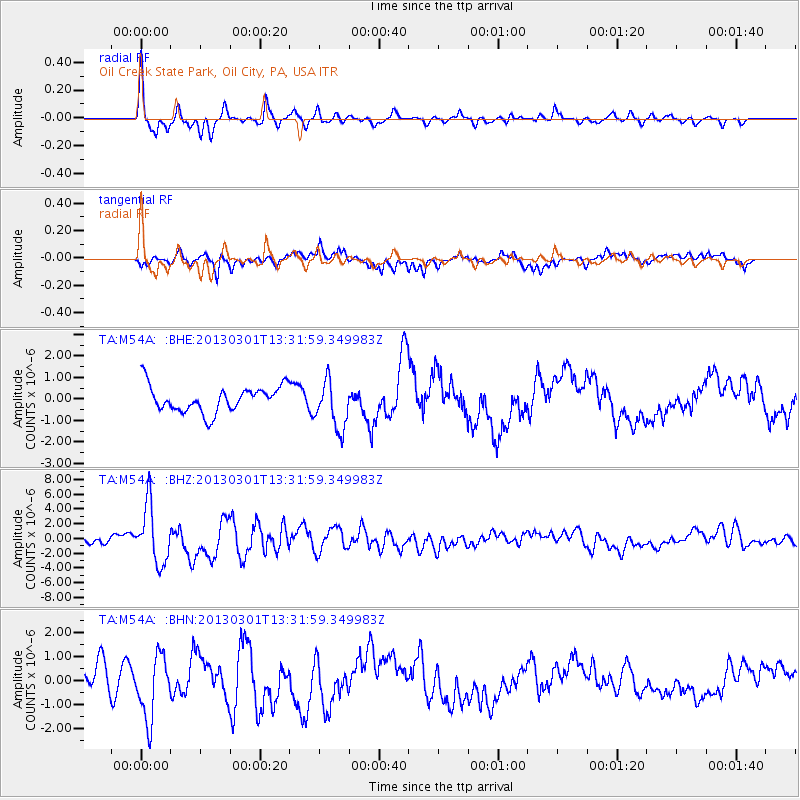
M54A Oil Creek State Park, Oil City, PA, USA - Earthquake Result Viewer

| Earthquake location: |
Kuril Islands |
| Earthquake latitude/longitude: |
51.0/157.4 |
| Earthquake time(UTC): |
2013/03/01 (060) 13:20:49 GMT |
| Earthquake Depth: |
29 km |
| Earthquake Magnitude: |
6.3 MB, 6.3 MS, 6.5 MW, 6.4 MW |
| Earthquake Catalog/Contributor: |
WHDF/NEIC |
|
| Network: |
TA USArray Transportable Network (new EarthScope stations) |
| Station: |
M54A Oil Creek State Park, Oil City, PA, USA |
| Lat/Lon: |
41.51 N/79.66 W |
| Elevation: |
488 m |
|
| Distance: |
75.3 deg |
| Az: |
40.666 deg |
| Baz: |
326.72 deg |
| Ray Param: |
0.051701803 |
| Estimated Moho Depth: |
47.75 km |
| Estimated Crust Vp/Vs: |
1.80 |
| Assumed Crust Vp: |
6.121 km/s |
| Estimated Crust Vs: |
3.396 km/s |
| Estimated Crust Poisson's Ratio: |
0.28 |
|
| Radial Match: |
84.72316 % |
| Radial Bump: |
303 |
| Transverse Match: |
45.765087 % |
| Transverse Bump: |
359 |
| SOD ConfigId: |
494114 |
| Insert Time: |
2013-05-15 07:08:05.414 +0000 |
| GWidth: |
2.5 |
| Max Bumps: |
400 |
| Tol: |
0.001 |
|
Signal To Noise
| Channel | StoN | STA | LTA |
| TA:M54A: :BHZ:20130301T13:31:59.349983Z | 12.103969 | 3.9478205E-6 | 3.2615915E-7 |
| TA:M54A: :BHN:20130301T13:31:59.349983Z | 3.0149324 | 1.3212789E-6 | 4.3824497E-7 |
| TA:M54A: :BHE:20130301T13:31:59.349983Z | 1.8704116 | 1.1298133E-6 | 6.040453E-7 |
| Arrivals |
| Ps | 6.4 SECOND |
| PpPs | 21 SECOND |
| PsPs/PpSs | 28 SECOND |


