You are here: Home > Network List > TA - USArray Transportable Network (new EarthScope stations) Stations List
> Station W41B Gary Mavity, Velonia, AR, USA > Earthquake Result Viewer
W41B Gary Mavity, Velonia, AR, USA - Earthquake Result Viewer
| Earthquake location: |
Kuril Islands |
| Earthquake latitude/longitude: |
51.0/157.4 |
| Earthquake time(UTC): |
2013/03/01 (060) 13:20:49 GMT |
| Earthquake Depth: |
29 km |
| Earthquake Magnitude: |
6.3 MB, 6.3 MS, 6.5 MW, 6.4 MW |
| Earthquake Catalog/Contributor: |
WHDF/NEIC |
|
| Network: |
TA USArray Transportable Network (new EarthScope stations) |
| Station: |
W41B Gary Mavity, Velonia, AR, USA |
| Lat/Lon: |
35.17 N/92.25 W |
| Elevation: |
95 m |
|
| Distance: |
74.7 deg |
| Az: |
52.787 deg |
| Baz: |
322.061 deg |
| Ray Param: |
0.05212699 |
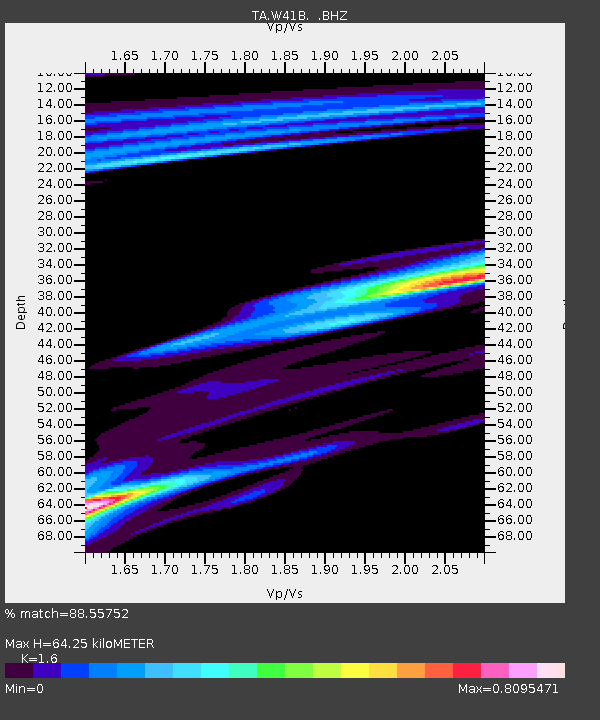
| Estimated Moho Depth: |
64.25 km |
| Estimated Crust Vp/Vs: |
1.60 |
| Assumed Crust Vp: |
6.498 km/s |
| Estimated Crust Vs: |
4.061 km/s |
| Estimated Crust Poisson's Ratio: |
0.18 |
|
| Radial Match: |
88.55752 % |
| Radial Bump: |
316 |
| Transverse Match: |
38.967434 % |
| Transverse Bump: |
313 |
| SOD ConfigId: |
494114 |
| Insert Time: |
2013-05-15 07:08:56.883 +0000 |
| GWidth: |
2.5 |
| Max Bumps: |
400 |
| Tol: |
0.001 |
|
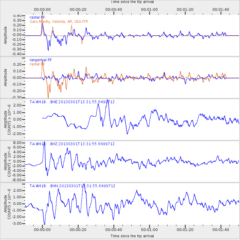
Signal To Noise
| Channel | StoN | STA | LTA |
| TA:W41B: :BHZ:20130301T13:31:55.649971Z | 4.701225 | 4.017201E-6 | 8.545009E-7 |
| TA:W41B: :BHN:20130301T13:31:55.649971Z | 1.9645534 | 1.5994478E-6 | 8.1415345E-7 |
| TA:W41B: :BHE:20130301T13:31:55.649971Z | 1.6097268 | 1.1954415E-6 | 7.426363E-7 |
| Arrivals |
| Ps | 6.2 SECOND |
| PpPs | 25 SECOND |
| PsPs/PpSs | 31 SECOND |


