You are here: Home > Network List > TA - USArray Transportable Network (new EarthScope stations) Stations List
> Station K39A Oelwein, IA, USA > Earthquake Result Viewer
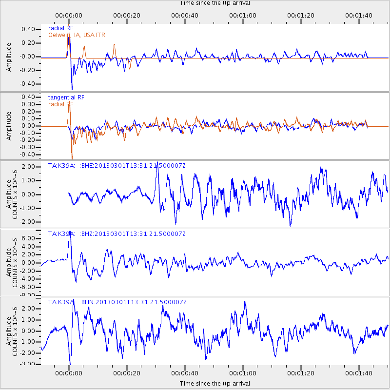
K39A Oelwein, IA, USA - Earthquake Result Viewer
*The percent match for this event was below the threshold and hence no stack was calculated.
| Earthquake location: |
Kuril Islands |
| Earthquake latitude/longitude: |
51.0/157.4 |
| Earthquake time(UTC): |
2013/03/01 (060) 13:20:49 GMT |
| Earthquake Depth: |
29 km |
| Earthquake Magnitude: |
6.3 MB, 6.3 MS, 6.5 MW, 6.4 MW |
| Earthquake Catalog/Contributor: |
WHDF/NEIC |
|
| Network: |
TA USArray Transportable Network (new EarthScope stations) |
| Station: |
K39A Oelwein, IA, USA |
| Lat/Lon: |
42.71 N/91.89 W |
| Elevation: |
332 m |
|
| Distance: |
69.0 deg |
| Az: |
47.617 deg |
| Baz: |
320.672 deg |
| Ray Param: |
$rayparam |
*The percent match for this event was below the threshold and hence was not used in the summary stack. |
|
| Radial Match: |
77.433815 % |
| Radial Bump: |
400 |
| Transverse Match: |
65.971535 % |
| Transverse Bump: |
369 |
| SOD ConfigId: |
494114 |
| Insert Time: |
2013-05-15 07:10:31.520 +0000 |
| GWidth: |
2.5 |
| Max Bumps: |
400 |
| Tol: |
0.001 |
|
Signal To Noise
| Channel | StoN | STA | LTA |
| TA:K39A: :BHZ:20130301T13:31:21.500007Z | 5.669864 | 3.441691E-6 | 6.070147E-7 |
| TA:K39A: :BHN:20130301T13:31:21.500007Z | 2.3498843 | 1.5819587E-6 | 6.732071E-7 |
| TA:K39A: :BHE:20130301T13:31:21.500007Z | 3.7290199 | 1.0875125E-6 | 2.9163493E-7 |
| Arrivals |
| Ps | |
| PpPs | |
| PsPs/PpSs | |


