You are here: Home > Network List > TA - USArray Transportable Network (new EarthScope stations) Stations List
> Station L39A Vinton, IA, USA > Earthquake Result Viewer
L39A Vinton, IA, USA - Earthquake Result Viewer
| Earthquake location: |
Kuril Islands |
| Earthquake latitude/longitude: |
51.0/157.4 |
| Earthquake time(UTC): |
2013/03/01 (060) 13:20:49 GMT |
| Earthquake Depth: |
29 km |
| Earthquake Magnitude: |
6.3 MB, 6.3 MS, 6.5 MW, 6.4 MW |
| Earthquake Catalog/Contributor: |
WHDF/NEIC |
|
| Network: |
TA USArray Transportable Network (new EarthScope stations) |
| Station: |
L39A Vinton, IA, USA |
| Lat/Lon: |
42.12 N/92.00 W |
| Elevation: |
261 m |
|
| Distance: |
69.4 deg |
| Az: |
48.08 deg |
| Baz: |
320.761 deg |
| Ray Param: |
0.055644106 |
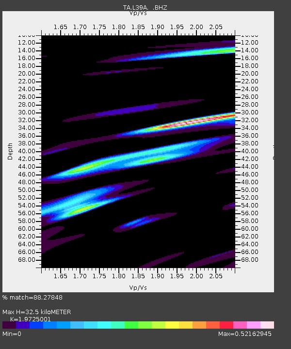
| Estimated Moho Depth: |
32.5 km |
| Estimated Crust Vp/Vs: |
1.97 |
| Assumed Crust Vp: |
6.53 km/s |
| Estimated Crust Vs: |
3.311 km/s |
| Estimated Crust Poisson's Ratio: |
0.33 |
|
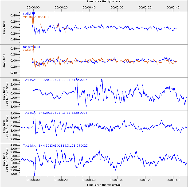
| Radial Match: |
88.27848 % |
| Radial Bump: |
400 |
| Transverse Match: |
60.765797 % |
| Transverse Bump: |
355 |
| SOD ConfigId: |
494114 |
| Insert Time: |
2013-05-15 07:10:43.302 +0000 |
| GWidth: |
2.5 |
| Max Bumps: |
400 |
| Tol: |
0.001 |
|
Signal To Noise
| Channel | StoN | STA | LTA |
| TA:L39A: :BHZ:20130301T13:31:23.95002Z | 6.989507 | 4.630812E-6 | 6.625377E-7 |
| TA:L39A: :BHN:20130301T13:31:23.95002Z | 5.415919 | 1.9978704E-6 | 3.6888855E-7 |
| TA:L39A: :BHE:20130301T13:31:23.95002Z | 2.6137106 | 1.6055669E-6 | 6.1428636E-7 |
| Arrivals |
| Ps | 5.0 SECOND |
| PpPs | 14 SECOND |
| PsPs/PpSs | 19 SECOND |


