You are here: Home > Network List > TA - USArray Transportable Network (new EarthScope stations) Stations List
> Station I41A Arkdale, WI, USA > Earthquake Result Viewer
I41A Arkdale, WI, USA - Earthquake Result Viewer

| Earthquake location: |
Kuril Islands |
| Earthquake latitude/longitude: |
51.0/157.4 |
| Earthquake time(UTC): |
2013/03/01 (060) 13:20:49 GMT |
| Earthquake Depth: |
29 km |
| Earthquake Magnitude: |
6.3 MB, 6.3 MS, 6.5 MW, 6.4 MW |
| Earthquake Catalog/Contributor: |
WHDF/NEIC |
|
| Network: |
TA USArray Transportable Network (new EarthScope stations) |
| Station: |
I41A Arkdale, WI, USA |
| Lat/Lon: |
44.06 N/89.87 W |
| Elevation: |
289 m |
|
| Distance: |
68.9 deg |
| Az: |
45.478 deg |
| Baz: |
321.285 deg |
| Ray Param: |
0.05598753 |
| Estimated Moho Depth: |
40.5 km |
| Estimated Crust Vp/Vs: |
1.75 |
| Assumed Crust Vp: |
6.41 km/s |
| Estimated Crust Vs: |
3.668 km/s |
| Estimated Crust Poisson's Ratio: |
0.26 |
|
| Radial Match: |
86.88307 % |
| Radial Bump: |
400 |
| Transverse Match: |
76.29025 % |
| Transverse Bump: |
400 |
| SOD ConfigId: |
494114 |
| Insert Time: |
2013-05-15 07:12:31.996 +0000 |
| GWidth: |
2.5 |
| Max Bumps: |
400 |
| Tol: |
0.001 |
|
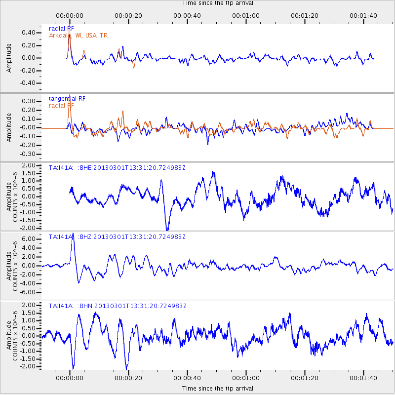
Signal To Noise
| Channel | StoN | STA | LTA |
| TA:I41A: :BHZ:20130301T13:31:20.724983Z | 7.872282 | 3.239026E-6 | 4.1144688E-7 |
| TA:I41A: :BHN:20130301T13:31:20.724983Z | 3.427041 | 9.850925E-7 | 2.874469E-7 |
| TA:I41A: :BHE:20130301T13:31:20.724983Z | 3.154417 | 1.1314705E-6 | 3.58694E-7 |
| Arrivals |
| Ps | 4.9 SECOND |
| PpPs | 17 SECOND |
| PsPs/PpSs | 22 SECOND |


