You are here: Home > Network List > TA - USArray Transportable Network (new EarthScope stations) Stations List
> Station TOLK Toolik Lake Research Station, AK, USA > Earthquake Result Viewer
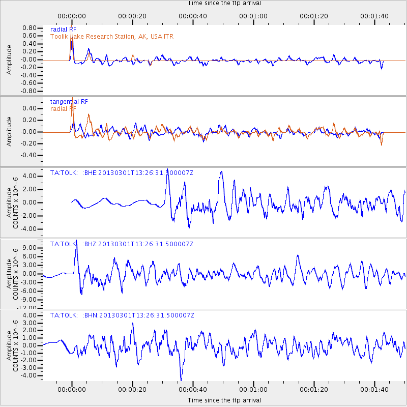
TOLK Toolik Lake Research Station, AK, USA - Earthquake Result Viewer
*The percent match for this event was below the threshold and hence no stack was calculated.
| Earthquake location: |
Kuril Islands |
| Earthquake latitude/longitude: |
51.0/157.4 |
| Earthquake time(UTC): |
2013/03/01 (060) 13:20:49 GMT |
| Earthquake Depth: |
29 km |
| Earthquake Magnitude: |
6.3 MB, 6.3 MS, 6.5 MW, 6.4 MW |
| Earthquake Catalog/Contributor: |
WHDF/NEIC |
|
| Network: |
TA USArray Transportable Network (new EarthScope stations) |
| Station: |
TOLK Toolik Lake Research Station, AK, USA |
| Lat/Lon: |
68.64 N/149.57 W |
| Elevation: |
760 m |
|
| Distance: |
30.7 deg |
| Az: |
35.011 deg |
| Baz: |
262.087 deg |
| Ray Param: |
$rayparam |
*The percent match for this event was below the threshold and hence was not used in the summary stack. |
|
| Radial Match: |
77.07396 % |
| Radial Bump: |
400 |
| Transverse Match: |
71.85452 % |
| Transverse Bump: |
400 |
| SOD ConfigId: |
494114 |
| Insert Time: |
2013-05-15 07:13:42.333 +0000 |
| GWidth: |
2.5 |
| Max Bumps: |
400 |
| Tol: |
0.001 |
|
Signal To Noise
| Channel | StoN | STA | LTA |
| TA:TOLK: :BHZ:20130301T13:26:31.500007Z | 7.1810336 | 4.4774315E-6 | 6.2350796E-7 |
| TA:TOLK: :BHN:20130301T13:26:31.500007Z | 2.031977 | 7.5544165E-7 | 3.7177668E-7 |
| TA:TOLK: :BHE:20130301T13:26:31.500007Z | 5.2964478 | 2.188333E-6 | 4.1316994E-7 |
| Arrivals |
| Ps | |
| PpPs | |
| PsPs/PpSs | |


