You are here: Home > Network List > TA - USArray Transportable Network (new EarthScope stations) Stations List
> Station O43A Sugar Creek Farm, Atlanta, IL, USA > Earthquake Result Viewer
O43A Sugar Creek Farm, Atlanta, IL, USA - Earthquake Result Viewer
| Earthquake location: |
Kuril Islands |
| Earthquake latitude/longitude: |
51.0/157.4 |
| Earthquake time(UTC): |
2013/03/01 (060) 13:20:49 GMT |
| Earthquake Depth: |
29 km |
| Earthquake Magnitude: |
6.3 MB, 6.3 MS, 6.5 MW, 6.4 MW |
| Earthquake Catalog/Contributor: |
WHDF/NEIC |
|
| Network: |
TA USArray Transportable Network (new EarthScope stations) |
| Station: |
O43A Sugar Creek Farm, Atlanta, IL, USA |
| Lat/Lon: |
40.29 N/89.31 W |
| Elevation: |
224 m |
|
| Distance: |
72.1 deg |
| Az: |
47.606 deg |
| Baz: |
322.369 deg |
| Ray Param: |
0.05385939 |
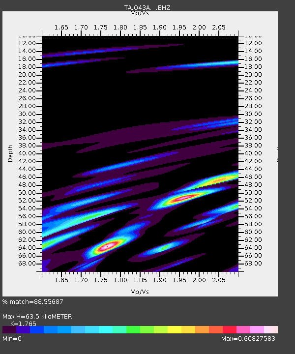
| Estimated Moho Depth: |
63.5 km |
| Estimated Crust Vp/Vs: |
1.76 |
| Assumed Crust Vp: |
6.498 km/s |
| Estimated Crust Vs: |
3.681 km/s |
| Estimated Crust Poisson's Ratio: |
0.26 |
|
| Radial Match: |
88.55687 % |
| Radial Bump: |
400 |
| Transverse Match: |
61.949276 % |
| Transverse Bump: |
400 |
| SOD ConfigId: |
494114 |
| Insert Time: |
2013-05-15 07:14:05.338 +0000 |
| GWidth: |
2.5 |
| Max Bumps: |
400 |
| Tol: |
0.001 |
|
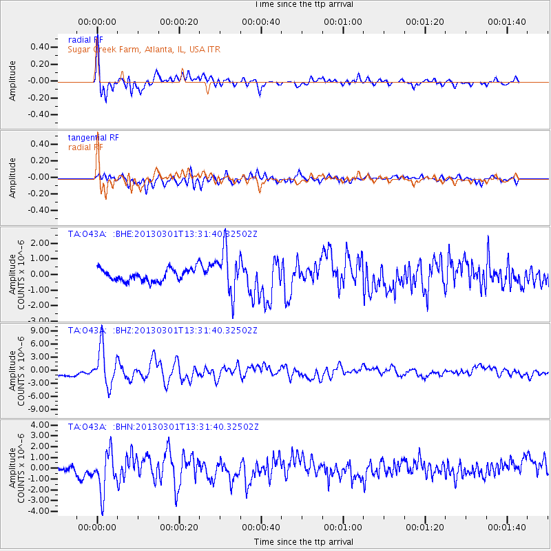
Signal To Noise
| Channel | StoN | STA | LTA |
| TA:O43A: :BHZ:20130301T13:31:40.32502Z | 5.957701 | 4.4502326E-6 | 7.469714E-7 |
| TA:O43A: :BHN:20130301T13:31:40.32502Z | 3.395834 | 1.8679729E-6 | 5.500778E-7 |
| TA:O43A: :BHE:20130301T13:31:40.32502Z | 3.732238 | 1.4423098E-6 | 3.8644635E-7 |
| Arrivals |
| Ps | 7.8 SECOND |
| PpPs | 26 SECOND |
| PsPs/PpSs | 34 SECOND |


