You are here: Home > Network List > TA - USArray Transportable Network (new EarthScope stations) Stations List
> Station E39A Mellen, WI, USA > Earthquake Result Viewer
E39A Mellen, WI, USA - Earthquake Result Viewer
| Earthquake location: |
Kuril Islands |
| Earthquake latitude/longitude: |
51.0/157.4 |
| Earthquake time(UTC): |
2013/03/01 (060) 13:20:49 GMT |
| Earthquake Depth: |
29 km |
| Earthquake Magnitude: |
6.3 MB, 6.3 MS, 6.5 MW, 6.4 MW |
| Earthquake Catalog/Contributor: |
WHDF/NEIC |
|
| Network: |
TA USArray Transportable Network (new EarthScope stations) |
| Station: |
E39A Mellen, WI, USA |
| Lat/Lon: |
46.38 N/90.56 W |
| Elevation: |
426 m |
|
| Distance: |
66.8 deg |
| Az: |
44.302 deg |
| Baz: |
320.355 deg |
| Ray Param: |
0.057362765 |
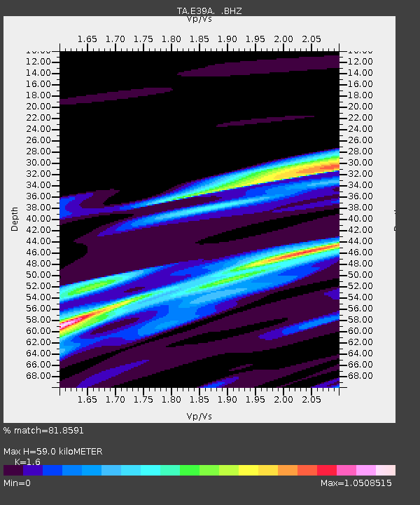
| Estimated Moho Depth: |
59.0 km |
| Estimated Crust Vp/Vs: |
1.60 |
| Assumed Crust Vp: |
6.467 km/s |
| Estimated Crust Vs: |
4.042 km/s |
| Estimated Crust Poisson's Ratio: |
0.18 |
|
| Radial Match: |
81.8591 % |
| Radial Bump: |
400 |
| Transverse Match: |
63.26227 % |
| Transverse Bump: |
356 |
| SOD ConfigId: |
494114 |
| Insert Time: |
2013-05-15 07:14:44.418 +0000 |
| GWidth: |
2.5 |
| Max Bumps: |
400 |
| Tol: |
0.001 |
|

Signal To Noise
| Channel | StoN | STA | LTA |
| TA:E39A: :BHZ:20130301T13:31:07.524971Z | 7.461557 | 3.0946915E-6 | 4.1475144E-7 |
| TA:E39A: :BHN:20130301T13:31:07.524971Z | 2.734686 | 1.1766437E-6 | 4.3026645E-7 |
| TA:E39A: :BHE:20130301T13:31:07.524971Z | 3.0448647 | 1.3143402E-6 | 4.3165804E-7 |
| Arrivals |
| Ps | 5.7 SECOND |
| PpPs | 23 SECOND |
| PsPs/PpSs | 28 SECOND |


