You are here: Home > Network List > AV - Alaska Volcano Observatory Stations List
> Station MAPS Pakushin Southeast, Makushin Volcano, Alaska > Earthquake Result Viewer
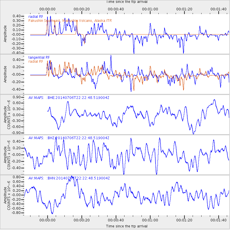
MAPS Pakushin Southeast, Makushin Volcano, Alaska - Earthquake Result Viewer
*The percent match for this event was below the threshold and hence no stack was calculated.
| Earthquake location: |
Vanuatu Islands Region |
| Earthquake latitude/longitude: |
-21.1/174.0 |
| Earthquake time(UTC): |
2014/07/06 (187) 22:11:29 GMT |
| Earthquake Depth: |
8.0 km |
| Earthquake Magnitude: |
5.7 Mwc, 5.0 mb, 5.5 Ms_20, 5.6 Mwb, 5.8 Mww |
| Earthquake Catalog/Contributor: |
ISC/ISC |
|
| Network: |
AV Alaska Volcano Observatory |
| Station: |
MAPS Pakushin Southeast, Makushin Volcano, Alaska |
| Lat/Lon: |
53.81 N/166.94 W |
| Elevation: |
333 m |
|
| Distance: |
76.4 deg |
| Az: |
11.519 deg |
| Baz: |
198.32 deg |
| Ray Param: |
$rayparam |
*The percent match for this event was below the threshold and hence was not used in the summary stack. |
|
| Radial Match: |
51.20744 % |
| Radial Bump: |
400 |
| Transverse Match: |
59.661484 % |
| Transverse Bump: |
345 |
| SOD ConfigId: |
3390531 |
| Insert Time: |
2019-04-12 17:43:45.148 +0000 |
| GWidth: |
2.5 |
| Max Bumps: |
400 |
| Tol: |
0.001 |
|
Signal To Noise
| Channel | StoN | STA | LTA |
| AV:MAPS: :BHZ:20140706T22:22:48.519004Z | 0.9077173 | 1.9153447E-7 | 2.1100675E-7 |
| AV:MAPS: :BHN:20140706T22:22:48.519004Z | 2.5258467 | 5.7923404E-7 | 2.2932272E-7 |
| AV:MAPS: :BHE:20140706T22:22:48.519004Z | 0.47020942 | 1.3448319E-7 | 2.8600698E-7 |
| Arrivals |
| Ps | |
| PpPs | |
| PsPs/PpSs | |


