You are here: Home > Network List > TA - USArray Transportable Network (new EarthScope stations) Stations List
> Station J43A Natural Harvest Farm, Hartford, WI, USA > Earthquake Result Viewer
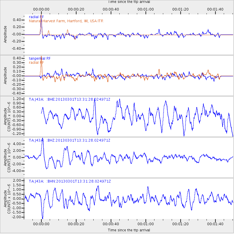
J43A Natural Harvest Farm, Hartford, WI, USA - Earthquake Result Viewer
| Earthquake location: |
Kuril Islands |
| Earthquake latitude/longitude: |
51.0/157.4 |
| Earthquake time(UTC): |
2013/03/01 (060) 13:20:49 GMT |
| Earthquake Depth: |
29 km |
| Earthquake Magnitude: |
6.3 MB, 6.3 MS, 6.5 MW, 6.4 MW |
| Earthquake Catalog/Contributor: |
WHDF/NEIC |
|
| Network: |
TA USArray Transportable Network (new EarthScope stations) |
| Station: |
J43A Natural Harvest Farm, Hartford, WI, USA |
| Lat/Lon: |
43.38 N/88.42 W |
| Elevation: |
322 m |
|
| Distance: |
70.0 deg |
| Az: |
45.045 deg |
| Baz: |
322.132 deg |
| Ray Param: |
0.055204004 |
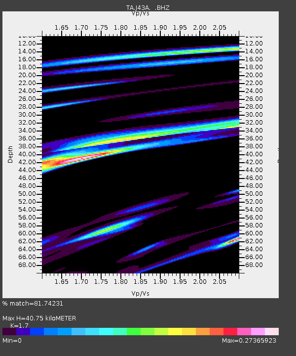
| Estimated Moho Depth: |
40.75 km |
| Estimated Crust Vp/Vs: |
1.70 |
| Assumed Crust Vp: |
6.571 km/s |
| Estimated Crust Vs: |
3.865 km/s |
| Estimated Crust Poisson's Ratio: |
0.24 |
|
| Radial Match: |
81.74231 % |
| Radial Bump: |
400 |
| Transverse Match: |
54.740177 % |
| Transverse Bump: |
400 |
| SOD ConfigId: |
494114 |
| Insert Time: |
2013-05-15 07:17:04.217 +0000 |
| GWidth: |
2.5 |
| Max Bumps: |
400 |
| Tol: |
0.001 |
|
Signal To Noise
| Channel | StoN | STA | LTA |
| TA:J43A: :BHZ:20130301T13:31:28.024971Z | 7.719947 | 2.761526E-6 | 3.577131E-7 |
| TA:J43A: :BHN:20130301T13:31:28.024971Z | 2.197621 | 8.969732E-7 | 4.0815644E-7 |
| TA:J43A: :BHE:20130301T13:31:28.024971Z | 2.1607316 | 7.171714E-7 | 3.319114E-7 |
| Arrivals |
| Ps | 4.5 SECOND |
| PpPs | 16 SECOND |
| PsPs/PpSs | 21 SECOND |


