You are here: Home > Network List > TA - USArray Transportable Network (new EarthScope stations) Stations List
> Station K43A Burlington, WI, USA > Earthquake Result Viewer
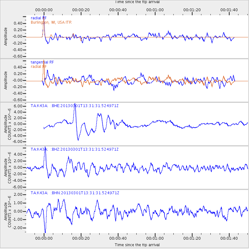
K43A Burlington, WI, USA - Earthquake Result Viewer
*The percent match for this event was below the threshold and hence no stack was calculated.
| Earthquake location: |
Kuril Islands |
| Earthquake latitude/longitude: |
51.0/157.4 |
| Earthquake time(UTC): |
2013/03/01 (060) 13:20:49 GMT |
| Earthquake Depth: |
29 km |
| Earthquake Magnitude: |
6.3 MB, 6.3 MS, 6.5 MW, 6.4 MW |
| Earthquake Catalog/Contributor: |
WHDF/NEIC |
|
| Network: |
TA USArray Transportable Network (new EarthScope stations) |
| Station: |
K43A Burlington, WI, USA |
| Lat/Lon: |
42.70 N/88.33 W |
| Elevation: |
264 m |
|
| Distance: |
70.6 deg |
| Az: |
45.432 deg |
| Baz: |
322.321 deg |
| Ray Param: |
$rayparam |
*The percent match for this event was below the threshold and hence was not used in the summary stack. |
|
| Radial Match: |
43.82365 % |
| Radial Bump: |
363 |
| Transverse Match: |
33.104347 % |
| Transverse Bump: |
400 |
| SOD ConfigId: |
494114 |
| Insert Time: |
2013-05-15 07:17:39.396 +0000 |
| GWidth: |
2.5 |
| Max Bumps: |
400 |
| Tol: |
0.001 |
|
Signal To Noise
| Channel | StoN | STA | LTA |
| TA:K43A: :BHZ:20130301T13:31:31.524971Z | 7.404337 | 2.588024E-6 | 3.4952814E-7 |
| TA:K43A: :BHN:20130301T13:31:31.524971Z | 3.7904584 | 1.0602698E-6 | 2.7972072E-7 |
| TA:K43A: :BHE:20130301T13:31:31.524971Z | 1.2564164 | 2.608603E-6 | 2.0762247E-6 |
| Arrivals |
| Ps | |
| PpPs | |
| PsPs/PpSs | |


