You are here: Home > Network List > TA - USArray Transportable Network (new EarthScope stations) Stations List
> Station M43A Waltham Township, Utica, IL, USA > Earthquake Result Viewer
M43A Waltham Township, Utica, IL, USA - Earthquake Result Viewer
| Earthquake location: |
Kuril Islands |
| Earthquake latitude/longitude: |
51.0/157.4 |
| Earthquake time(UTC): |
2013/03/01 (060) 13:20:49 GMT |
| Earthquake Depth: |
29 km |
| Earthquake Magnitude: |
6.3 MB, 6.3 MS, 6.5 MW, 6.4 MW |
| Earthquake Catalog/Contributor: |
WHDF/NEIC |
|
| Network: |
TA USArray Transportable Network (new EarthScope stations) |
| Station: |
M43A Waltham Township, Utica, IL, USA |
| Lat/Lon: |
41.44 N/88.96 W |
| Elevation: |
190 m |
|
| Distance: |
71.3 deg |
| Az: |
46.641 deg |
| Baz: |
322.297 deg |
| Ray Param: |
0.054357395 |
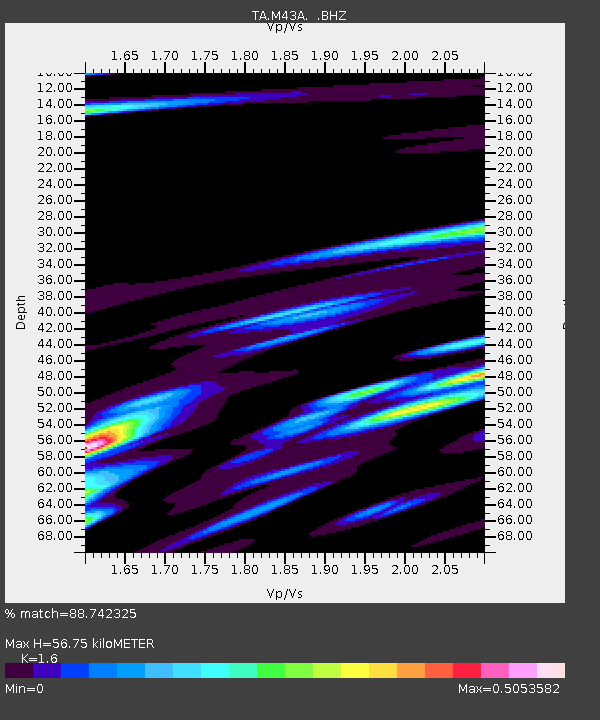
| Estimated Moho Depth: |
56.75 km |
| Estimated Crust Vp/Vs: |
1.60 |
| Assumed Crust Vp: |
6.498 km/s |
| Estimated Crust Vs: |
4.061 km/s |
| Estimated Crust Poisson's Ratio: |
0.18 |
|
| Radial Match: |
88.742325 % |
| Radial Bump: |
383 |
| Transverse Match: |
66.20463 % |
| Transverse Bump: |
400 |
| SOD ConfigId: |
494114 |
| Insert Time: |
2013-05-15 07:18:18.858 +0000 |
| GWidth: |
2.5 |
| Max Bumps: |
400 |
| Tol: |
0.001 |
|

Signal To Noise
| Channel | StoN | STA | LTA |
| TA:M43A: :BHZ:20130301T13:31:35.849983Z | 6.9037786 | 3.8125593E-6 | 5.522424E-7 |
| TA:M43A: :BHN:20130301T13:31:35.849983Z | 5.935604 | 1.6270365E-6 | 2.7411474E-7 |
| TA:M43A: :BHE:20130301T13:31:35.849983Z | 2.3674905 | 1.2673953E-6 | 5.3533273E-7 |
| Arrivals |
| Ps | 5.5 SECOND |
| PpPs | 22 SECOND |
| PsPs/PpSs | 27 SECOND |


