You are here: Home > Network List > TA - USArray Transportable Network (new EarthScope stations) Stations List
> Station Q47A Bedord North Lawrence Stars, Bedford, IN, USA > Earthquake Result Viewer
Q47A Bedord North Lawrence Stars, Bedford, IN, USA - Earthquake Result Viewer
| Earthquake location: |
Kuril Islands |
| Earthquake latitude/longitude: |
51.0/157.4 |
| Earthquake time(UTC): |
2013/03/01 (060) 13:20:49 GMT |
| Earthquake Depth: |
29 km |
| Earthquake Magnitude: |
6.3 MB, 6.3 MS, 6.5 MW, 6.4 MW |
| Earthquake Catalog/Contributor: |
WHDF/NEIC |
|
| Network: |
TA USArray Transportable Network (new EarthScope stations) |
| Station: |
Q47A Bedord North Lawrence Stars, Bedford, IN, USA |
| Lat/Lon: |
38.94 N/86.43 W |
| Elevation: |
230 m |
|
| Distance: |
74.5 deg |
| Az: |
46.587 deg |
| Baz: |
323.909 deg |
| Ray Param: |
0.052255977 |
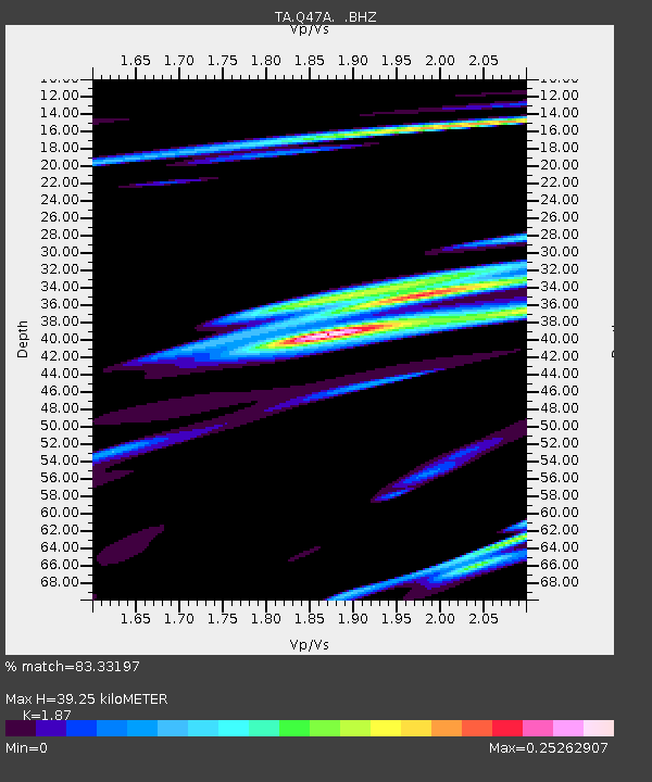
| Estimated Moho Depth: |
39.25 km |
| Estimated Crust Vp/Vs: |
1.87 |
| Assumed Crust Vp: |
6.444 km/s |
| Estimated Crust Vs: |
3.446 km/s |
| Estimated Crust Poisson's Ratio: |
0.30 |
|
| Radial Match: |
83.33197 % |
| Radial Bump: |
312 |
| Transverse Match: |
49.692642 % |
| Transverse Bump: |
328 |
| SOD ConfigId: |
494114 |
| Insert Time: |
2013-05-15 07:18:28.741 +0000 |
| GWidth: |
2.5 |
| Max Bumps: |
400 |
| Tol: |
0.001 |
|
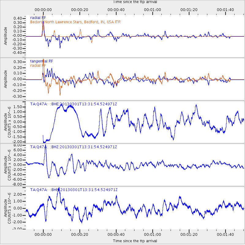
Signal To Noise
| Channel | StoN | STA | LTA |
| TA:Q47A: :BHZ:20130301T13:31:54.524971Z | 4.4613295 | 3.684857E-6 | 8.259549E-7 |
| TA:Q47A: :BHN:20130301T13:31:54.524971Z | 2.1528566 | 1.1448064E-6 | 5.317616E-7 |
| TA:Q47A: :BHE:20130301T13:31:54.524971Z | 0.7660672 | 1.0348864E-6 | 1.3509081E-6 |
| Arrivals |
| Ps | 5.5 SECOND |
| PpPs | 17 SECOND |
| PsPs/PpSs | 22 SECOND |


