You are here: Home > Network List > TA - USArray Transportable Network (new EarthScope stations) Stations List
> Station T48A Bowling Green, KY, USA > Earthquake Result Viewer
T48A Bowling Green, KY, USA - Earthquake Result Viewer
| Earthquake location: |
Kuril Islands |
| Earthquake latitude/longitude: |
51.0/157.4 |
| Earthquake time(UTC): |
2013/03/01 (060) 13:20:49 GMT |
| Earthquake Depth: |
29 km |
| Earthquake Magnitude: |
6.3 MB, 6.3 MS, 6.5 MW, 6.4 MW |
| Earthquake Catalog/Contributor: |
WHDF/NEIC |
|
| Network: |
TA USArray Transportable Network (new EarthScope stations) |
| Station: |
T48A Bowling Green, KY, USA |
| Lat/Lon: |
37.11 N/86.39 W |
| Elevation: |
218 m |
|
| Distance: |
76.0 deg |
| Az: |
47.673 deg |
| Baz: |
324.205 deg |
| Ray Param: |
0.05125993 |
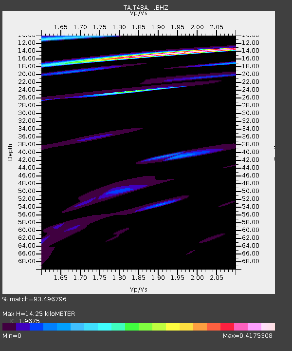
| Estimated Moho Depth: |
14.25 km |
| Estimated Crust Vp/Vs: |
1.97 |
| Assumed Crust Vp: |
6.444 km/s |
| Estimated Crust Vs: |
3.275 km/s |
| Estimated Crust Poisson's Ratio: |
0.33 |
|
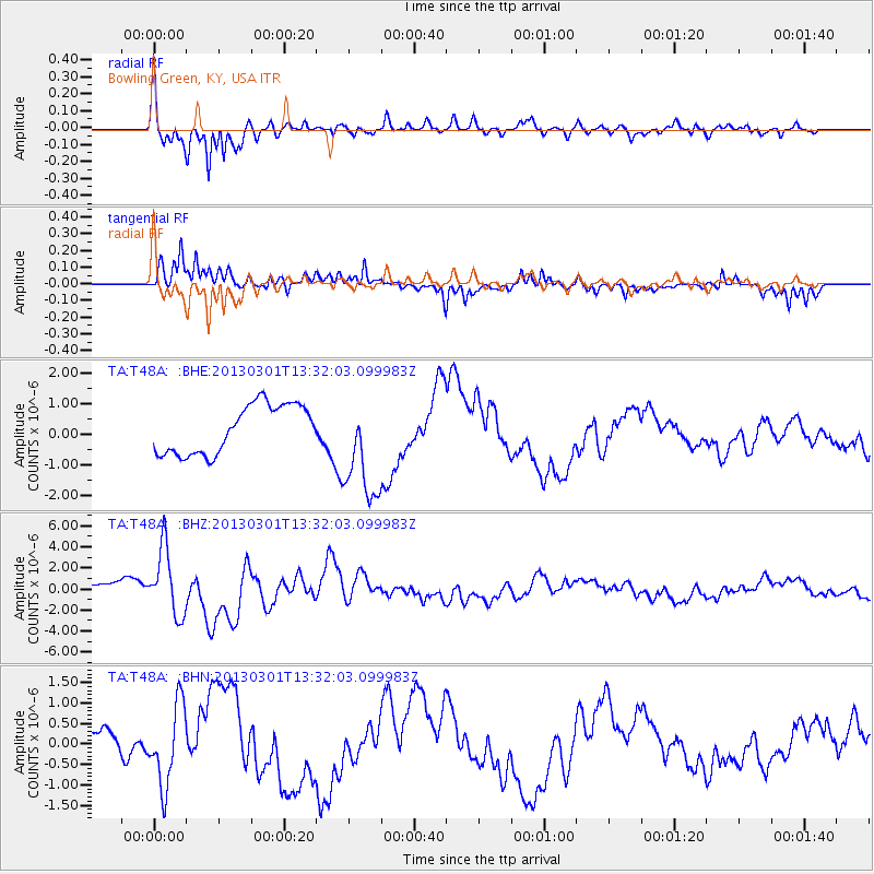
| Radial Match: |
93.496796 % |
| Radial Bump: |
400 |
| Transverse Match: |
69.7362 % |
| Transverse Bump: |
400 |
| SOD ConfigId: |
494114 |
| Insert Time: |
2013-05-15 07:18:54.341 +0000 |
| GWidth: |
2.5 |
| Max Bumps: |
400 |
| Tol: |
0.001 |
|
Signal To Noise
| Channel | StoN | STA | LTA |
| TA:T48A: :BHZ:20130301T13:32:03.099983Z | 5.7353845 | 3.1882223E-6 | 5.558864E-7 |
| TA:T48A: :BHN:20130301T13:32:03.099983Z | 2.4949937 | 9.732008E-7 | 3.9006142E-7 |
| TA:T48A: :BHE:20130301T13:32:03.099983Z | 2.1808107 | 1.7285573E-6 | 7.9262145E-7 |
| Arrivals |
| Ps | 2.2 SECOND |
| PpPs | 6.4 SECOND |
| PsPs/PpSs | 8.6 SECOND |


