You are here: Home > Network List > TA - USArray Transportable Network (new EarthScope stations) Stations List
> Station T47A Sharon Grove, KY, USA > Earthquake Result Viewer
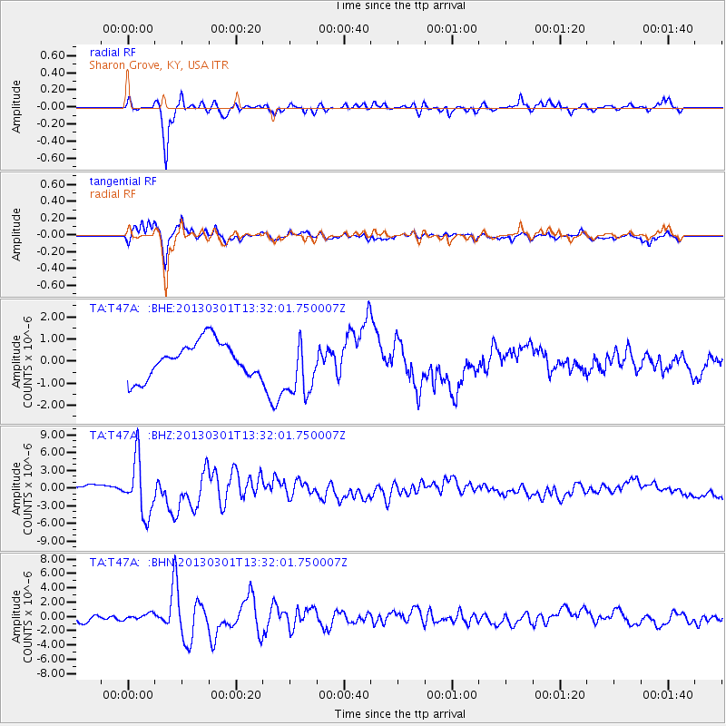
T47A Sharon Grove, KY, USA - Earthquake Result Viewer
*The percent match for this event was below the threshold and hence no stack was calculated.
| Earthquake location: |
Kuril Islands |
| Earthquake latitude/longitude: |
51.0/157.4 |
| Earthquake time(UTC): |
2013/03/01 (060) 13:20:49 GMT |
| Earthquake Depth: |
29 km |
| Earthquake Magnitude: |
6.3 MB, 6.3 MS, 6.5 MW, 6.4 MW |
| Earthquake Catalog/Contributor: |
WHDF/NEIC |
|
| Network: |
TA USArray Transportable Network (new EarthScope stations) |
| Station: |
T47A Sharon Grove, KY, USA |
| Lat/Lon: |
36.99 N/87.11 W |
| Elevation: |
217 m |
|
| Distance: |
75.8 deg |
| Az: |
48.221 deg |
| Baz: |
323.913 deg |
| Ray Param: |
$rayparam |
*The percent match for this event was below the threshold and hence was not used in the summary stack. |
|
| Radial Match: |
86.40242 % |
| Radial Bump: |
302 |
| Transverse Match: |
84.06805 % |
| Transverse Bump: |
384 |
| SOD ConfigId: |
494114 |
| Insert Time: |
2013-05-15 07:19:05.083 +0000 |
| GWidth: |
2.5 |
| Max Bumps: |
400 |
| Tol: |
0.001 |
|
Signal To Noise
| Channel | StoN | STA | LTA |
| TA:T47A: :BHZ:20130301T13:32:01.750007Z | 6.38746 | 4.6633E-6 | 7.3007106E-7 |
| TA:T47A: :BHN:20130301T13:32:01.750007Z | 0.8219969 | 4.5560702E-7 | 5.542685E-7 |
| TA:T47A: :BHE:20130301T13:32:01.750007Z | 1.6340175 | 1.2936295E-6 | 7.916865E-7 |
| Arrivals |
| Ps | |
| PpPs | |
| PsPs/PpSs | |


