You are here: Home > Network List > TA - USArray Transportable Network (new EarthScope stations) Stations List
> Station R47A Wooly Knot Farm, English, IN, USA > Earthquake Result Viewer
R47A Wooly Knot Farm, English, IN, USA - Earthquake Result Viewer
| Earthquake location: |
Kuril Islands |
| Earthquake latitude/longitude: |
51.0/157.4 |
| Earthquake time(UTC): |
2013/03/01 (060) 13:20:49 GMT |
| Earthquake Depth: |
29 km |
| Earthquake Magnitude: |
6.3 MB, 6.3 MS, 6.5 MW, 6.4 MW |
| Earthquake Catalog/Contributor: |
WHDF/NEIC |
|
| Network: |
TA USArray Transportable Network (new EarthScope stations) |
| Station: |
R47A Wooly Knot Farm, English, IN, USA |
| Lat/Lon: |
38.30 N/86.53 W |
| Elevation: |
181 m |
|
| Distance: |
75.0 deg |
| Az: |
47.043 deg |
| Baz: |
323.967 deg |
| Ray Param: |
0.05194177 |
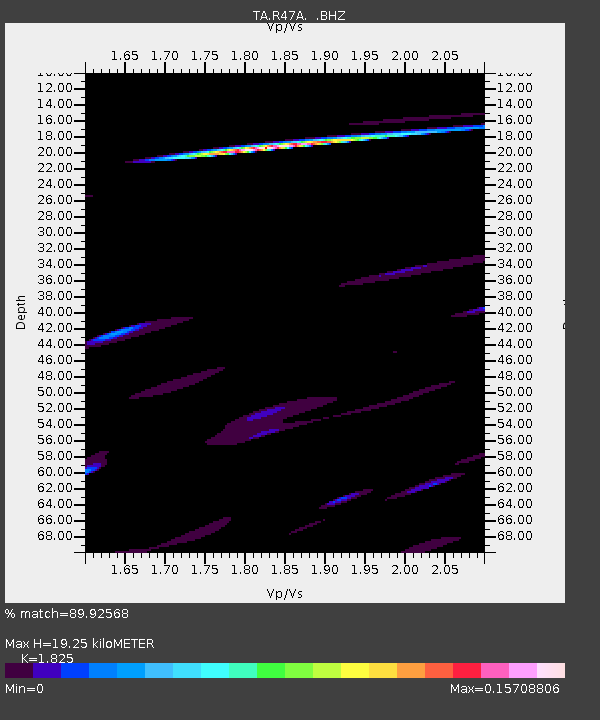
| Estimated Moho Depth: |
19.25 km |
| Estimated Crust Vp/Vs: |
1.83 |
| Assumed Crust Vp: |
6.444 km/s |
| Estimated Crust Vs: |
3.531 km/s |
| Estimated Crust Poisson's Ratio: |
0.29 |
|
| Radial Match: |
89.92568 % |
| Radial Bump: |
309 |
| Transverse Match: |
78.18094 % |
| Transverse Bump: |
297 |
| SOD ConfigId: |
494114 |
| Insert Time: |
2013-05-15 07:19:24.913 +0000 |
| GWidth: |
2.5 |
| Max Bumps: |
400 |
| Tol: |
0.001 |
|

Signal To Noise
| Channel | StoN | STA | LTA |
| TA:R47A: :BHZ:20130301T13:31:57.250007Z | 4.383236 | 3.897591E-6 | 8.89204E-7 |
| TA:R47A: :BHN:20130301T13:31:57.250007Z | 4.7807775 | 1.4904946E-6 | 3.1176825E-7 |
| TA:R47A: :BHE:20130301T13:31:57.250007Z | 0.9338155 | 1.3670933E-6 | 1.4639866E-6 |
| Arrivals |
| Ps | 2.5 SECOND |
| PpPs | 8.2 SECOND |
| PsPs/PpSs | 11 SECOND |


