You are here: Home > Network List > TA - USArray Transportable Network (new EarthScope stations) Stations List
> Station U47A Clarksville, TN, USA > Earthquake Result Viewer
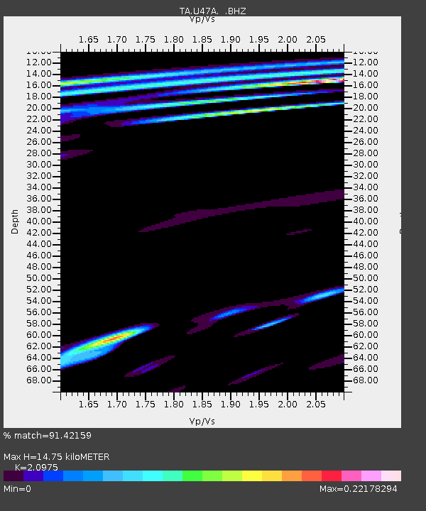
U47A Clarksville, TN, USA - Earthquake Result Viewer
| Earthquake location: |
Kuril Islands |
| Earthquake latitude/longitude: |
51.0/157.4 |
| Earthquake time(UTC): |
2013/03/01 (060) 13:20:49 GMT |
| Earthquake Depth: |
29 km |
| Earthquake Magnitude: |
6.3 MB, 6.3 MS, 6.5 MW, 6.4 MW |
| Earthquake Catalog/Contributor: |
WHDF/NEIC |
|
| Network: |
TA USArray Transportable Network (new EarthScope stations) |
| Station: |
U47A Clarksville, TN, USA |
| Lat/Lon: |
36.44 N/87.29 W |
| Elevation: |
145 m |
|
| Distance: |
76.1 deg |
| Az: |
48.676 deg |
| Baz: |
323.914 deg |
| Ray Param: |
0.051180147 |
| Estimated Moho Depth: |
14.75 km |
| Estimated Crust Vp/Vs: |
2.10 |
| Assumed Crust Vp: |
6.444 km/s |
| Estimated Crust Vs: |
3.072 km/s |
| Estimated Crust Poisson's Ratio: |
0.35 |
|
| Radial Match: |
91.42159 % |
| Radial Bump: |
283 |
| Transverse Match: |
57.701004 % |
| Transverse Bump: |
379 |
| SOD ConfigId: |
494114 |
| Insert Time: |
2013-05-15 07:19:26.611 +0000 |
| GWidth: |
2.5 |
| Max Bumps: |
400 |
| Tol: |
0.001 |
|

Signal To Noise
| Channel | StoN | STA | LTA |
| TA:U47A: :BHZ:20130301T13:32:03.774971Z | 7.864057 | 4.0890864E-6 | 5.199716E-7 |
| TA:U47A: :BHN:20130301T13:32:03.774971Z | 2.0109093 | 1.0636963E-6 | 5.2896286E-7 |
| TA:U47A: :BHE:20130301T13:32:03.774971Z | 1.6895394 | 1.2177971E-6 | 7.207865E-7 |
| Arrivals |
| Ps | 2.6 SECOND |
| PpPs | 6.9 SECOND |
| PsPs/PpSs | 9.5 SECOND |


