You are here: Home > Network List > TA - USArray Transportable Network (new EarthScope stations) Stations List
> Station 351A Pinckard, AL, USA > Earthquake Result Viewer
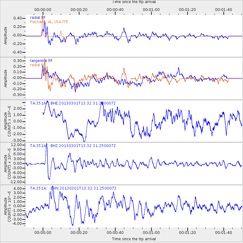
351A Pinckard, AL, USA - Earthquake Result Viewer
*The percent match for this event was below the threshold and hence no stack was calculated.
| Earthquake location: |
Kuril Islands |
| Earthquake latitude/longitude: |
51.0/157.4 |
| Earthquake time(UTC): |
2013/03/01 (060) 13:20:49 GMT |
| Earthquake Depth: |
29 km |
| Earthquake Magnitude: |
6.3 MB, 6.3 MS, 6.5 MW, 6.4 MW |
| Earthquake Catalog/Contributor: |
WHDF/NEIC |
|
| Network: |
TA USArray Transportable Network (new EarthScope stations) |
| Station: |
351A Pinckard, AL, USA |
| Lat/Lon: |
31.28 N/85.60 W |
| Elevation: |
48 m |
|
| Distance: |
81.1 deg |
| Az: |
50.556 deg |
| Baz: |
325.221 deg |
| Ray Param: |
$rayparam |
*The percent match for this event was below the threshold and hence was not used in the summary stack. |
|
| Radial Match: |
86.89736 % |
| Radial Bump: |
400 |
| Transverse Match: |
32.585934 % |
| Transverse Bump: |
400 |
| SOD ConfigId: |
494114 |
| Insert Time: |
2013-05-15 07:21:36.092 +0000 |
| GWidth: |
2.5 |
| Max Bumps: |
400 |
| Tol: |
0.001 |
|
Signal To Noise
| Channel | StoN | STA | LTA |
| TA:351A: :BHZ:20130301T13:32:31.250007Z | 17.727913 | 6.2250037E-6 | 3.5114138E-7 |
| TA:351A: :BHN:20130301T13:32:31.250007Z | 0.95220494 | 1.2719618E-6 | 1.3358067E-6 |
| TA:351A: :BHE:20130301T13:32:31.250007Z | 1.0313685 | 1.8826247E-6 | 1.8253656E-6 |
| Arrivals |
| Ps | |
| PpPs | |
| PsPs/PpSs | |


