You are here: Home > Network List > TA - USArray Transportable Network (new EarthScope stations) Stations List
> Station 556A Lake Butler, FL, USA > Earthquake Result Viewer
556A Lake Butler, FL, USA - Earthquake Result Viewer
| Earthquake location: |
Kuril Islands |
| Earthquake latitude/longitude: |
51.0/157.4 |
| Earthquake time(UTC): |
2013/03/01 (060) 13:20:49 GMT |
| Earthquake Depth: |
29 km |
| Earthquake Magnitude: |
6.3 MB, 6.3 MS, 6.5 MW, 6.4 MW |
| Earthquake Catalog/Contributor: |
WHDF/NEIC |
|
| Network: |
TA USArray Transportable Network (new EarthScope stations) |
| Station: |
556A Lake Butler, FL, USA |
| Lat/Lon: |
30.00 N/82.41 W |
| Elevation: |
45 m |
|
| Distance: |
83.7 deg |
| Az: |
48.97 deg |
| Baz: |
326.634 deg |
| Ray Param: |
0.045956805 |
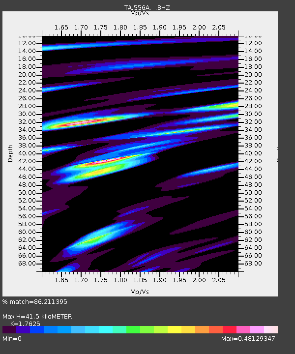
| Estimated Moho Depth: |
41.5 km |
| Estimated Crust Vp/Vs: |
1.76 |
| Assumed Crust Vp: |
6.565 km/s |
| Estimated Crust Vs: |
3.725 km/s |
| Estimated Crust Poisson's Ratio: |
0.26 |
|
| Radial Match: |
86.211395 % |
| Radial Bump: |
400 |
| Transverse Match: |
54.362537 % |
| Transverse Bump: |
314 |
| SOD ConfigId: |
494114 |
| Insert Time: |
2013-05-15 07:22:00.317 +0000 |
| GWidth: |
2.5 |
| Max Bumps: |
400 |
| Tol: |
0.001 |
|

Signal To Noise
| Channel | StoN | STA | LTA |
| TA:556A: :BHZ:20130301T13:32:44.750007Z | 10.971906 | 4.1364533E-6 | 3.7700408E-7 |
| TA:556A: :BHN:20130301T13:32:44.750007Z | 3.9380312 | 1.7194368E-6 | 4.3662345E-7 |
| TA:556A: :BHE:20130301T13:32:44.750007Z | 2.6121387 | 1.369783E-6 | 5.243914E-7 |
| Arrivals |
| Ps | 5.0 SECOND |
| PpPs | 17 SECOND |
| PsPs/PpSs | 22 SECOND |


