You are here: Home > Network List > TA - USArray Transportable Network (new EarthScope stations) Stations List
> Station 455A Stateville, GA, USA > Earthquake Result Viewer
455A Stateville, GA, USA - Earthquake Result Viewer

| Earthquake location: |
Kuril Islands |
| Earthquake latitude/longitude: |
51.0/157.4 |
| Earthquake time(UTC): |
2013/03/01 (060) 13:20:49 GMT |
| Earthquake Depth: |
29 km |
| Earthquake Magnitude: |
6.3 MB, 6.3 MS, 6.5 MW, 6.4 MW |
| Earthquake Catalog/Contributor: |
WHDF/NEIC |
|
| Network: |
TA USArray Transportable Network (new EarthScope stations) |
| Station: |
455A Stateville, GA, USA |
| Lat/Lon: |
30.74 N/83.03 W |
| Elevation: |
44 m |
|
| Distance: |
82.8 deg |
| Az: |
49.01 deg |
| Baz: |
326.326 deg |
| Ray Param: |
0.04659959 |
| Estimated Moho Depth: |
41.75 km |
| Estimated Crust Vp/Vs: |
1.86 |
| Assumed Crust Vp: |
6.565 km/s |
| Estimated Crust Vs: |
3.539 km/s |
| Estimated Crust Poisson's Ratio: |
0.30 |
|
| Radial Match: |
83.13929 % |
| Radial Bump: |
400 |
| Transverse Match: |
21.129725 % |
| Transverse Bump: |
284 |
| SOD ConfigId: |
494114 |
| Insert Time: |
2013-05-15 07:22:34.022 +0000 |
| GWidth: |
2.5 |
| Max Bumps: |
400 |
| Tol: |
0.001 |
|
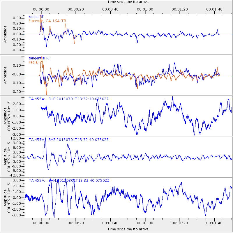
Signal To Noise
| Channel | StoN | STA | LTA |
| TA:455A: :BHZ:20130301T13:32:40.07502Z | 8.567472 | 5.523849E-6 | 6.447466E-7 |
| TA:455A: :BHN:20130301T13:32:40.07502Z | 2.5486991 | 1.5641945E-6 | 6.1372265E-7 |
| TA:455A: :BHE:20130301T13:32:40.07502Z | 1.666093 | 1.2467658E-6 | 7.4831706E-7 |
| Arrivals |
| Ps | 5.6 SECOND |
| PpPs | 18 SECOND |
| PsPs/PpSs | 23 SECOND |


