You are here: Home > Network List > TA - USArray Transportable Network (new EarthScope stations) Stations List
> Station 454A Quitman, GA, USA > Earthquake Result Viewer
454A Quitman, GA, USA - Earthquake Result Viewer
| Earthquake location: |
Kuril Islands |
| Earthquake latitude/longitude: |
51.0/157.4 |
| Earthquake time(UTC): |
2013/03/01 (060) 13:20:49 GMT |
| Earthquake Depth: |
29 km |
| Earthquake Magnitude: |
6.3 MB, 6.3 MS, 6.5 MW, 6.4 MW |
| Earthquake Catalog/Contributor: |
WHDF/NEIC |
|
| Network: |
TA USArray Transportable Network (new EarthScope stations) |
| Station: |
454A Quitman, GA, USA |
| Lat/Lon: |
30.71 N/83.63 W |
| Elevation: |
50 m |
|
| Distance: |
82.5 deg |
| Az: |
49.461 deg |
| Baz: |
326.077 deg |
| Ray Param: |
0.046784684 |
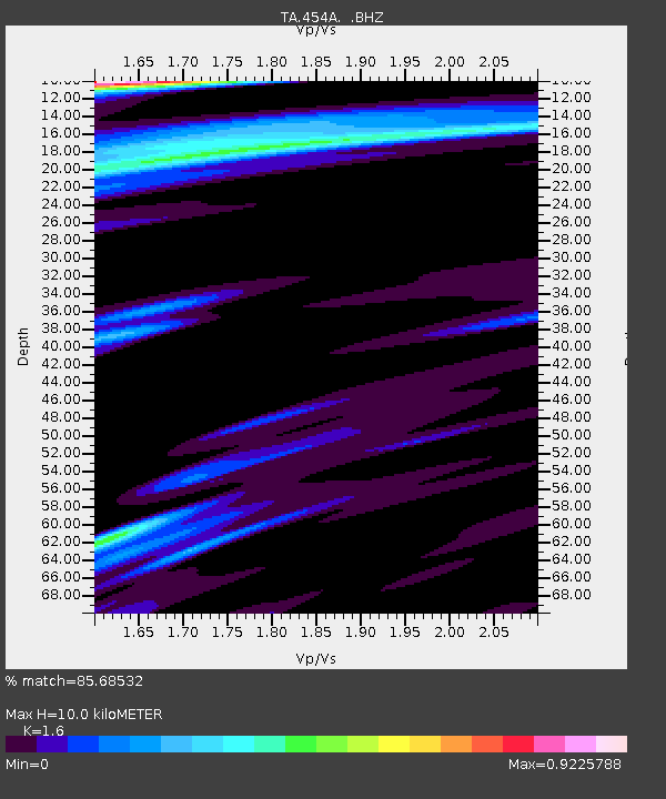
| Estimated Moho Depth: |
10.0 km |
| Estimated Crust Vp/Vs: |
1.60 |
| Assumed Crust Vp: |
6.565 km/s |
| Estimated Crust Vs: |
4.103 km/s |
| Estimated Crust Poisson's Ratio: |
0.18 |
|
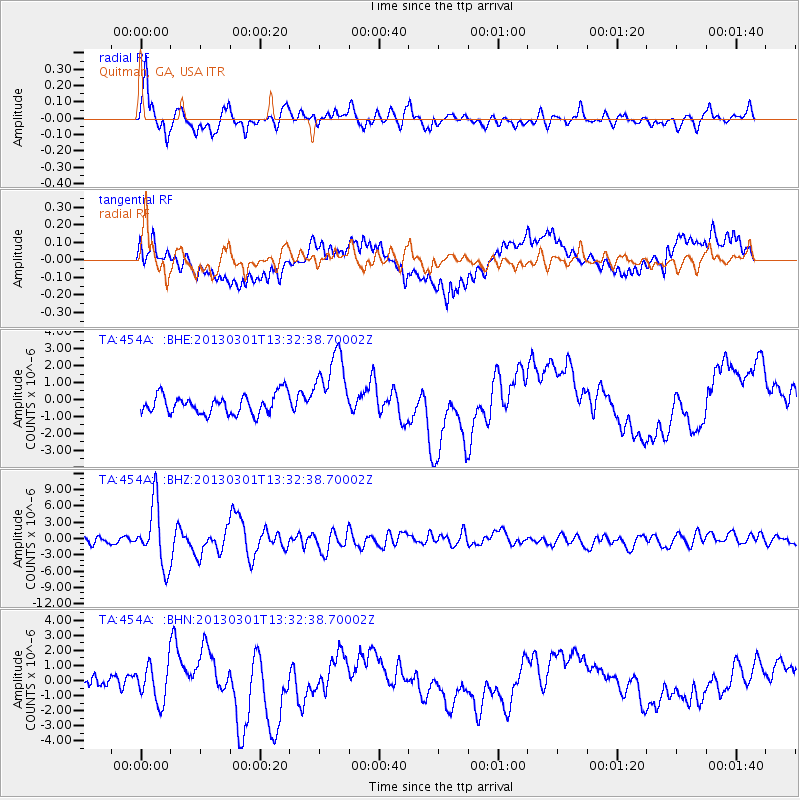
| Radial Match: |
85.68532 % |
| Radial Bump: |
400 |
| Transverse Match: |
50.439407 % |
| Transverse Bump: |
400 |
| SOD ConfigId: |
494114 |
| Insert Time: |
2013-05-15 07:22:46.040 +0000 |
| GWidth: |
2.5 |
| Max Bumps: |
400 |
| Tol: |
0.001 |
|
Signal To Noise
| Channel | StoN | STA | LTA |
| TA:454A: :BHZ:20130301T13:32:38.70002Z | 6.060891 | 5.6129775E-6 | 9.2609775E-7 |
| TA:454A: :BHN:20130301T13:32:38.70002Z | 2.470712 | 1.2364433E-6 | 5.004401E-7 |
| TA:454A: :BHE:20130301T13:32:38.70002Z | 3.7822583 | 2.148044E-6 | 5.6792624E-7 |
| Arrivals |
| Ps | 0.9 SECOND |
| PpPs | 3.8 SECOND |
| PsPs/PpSs | 4.8 SECOND |


