You are here: Home > Network List > TA - USArray Transportable Network (new EarthScope stations) Stations List
> Station 554A Perry, FL, USA > Earthquake Result Viewer
554A Perry, FL, USA - Earthquake Result Viewer
| Earthquake location: |
Kuril Islands |
| Earthquake latitude/longitude: |
51.0/157.4 |
| Earthquake time(UTC): |
2013/03/01 (060) 13:20:49 GMT |
| Earthquake Depth: |
29 km |
| Earthquake Magnitude: |
6.3 MB, 6.3 MS, 6.5 MW, 6.4 MW |
| Earthquake Catalog/Contributor: |
WHDF/NEIC |
|
| Network: |
TA USArray Transportable Network (new EarthScope stations) |
| Station: |
554A Perry, FL, USA |
| Lat/Lon: |
30.08 N/83.68 W |
| Elevation: |
12 m |
|
| Distance: |
83.0 deg |
| Az: |
49.853 deg |
| Baz: |
326.099 deg |
| Ray Param: |
0.04644036 |
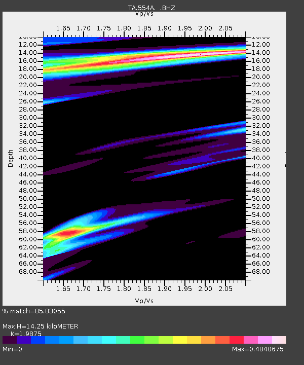
| Estimated Moho Depth: |
14.25 km |
| Estimated Crust Vp/Vs: |
1.99 |
| Assumed Crust Vp: |
6.565 km/s |
| Estimated Crust Vs: |
3.303 km/s |
| Estimated Crust Poisson's Ratio: |
0.33 |
|
| Radial Match: |
85.83055 % |
| Radial Bump: |
400 |
| Transverse Match: |
63.98657 % |
| Transverse Bump: |
400 |
| SOD ConfigId: |
494114 |
| Insert Time: |
2013-05-15 07:22:57.796 +0000 |
| GWidth: |
2.5 |
| Max Bumps: |
400 |
| Tol: |
0.001 |
|

Signal To Noise
| Channel | StoN | STA | LTA |
| TA:554A: :BHZ:20130301T13:32:41.250007Z | 7.744157 | 5.679835E-6 | 7.334349E-7 |
| TA:554A: :BHN:20130301T13:32:41.250007Z | 1.618293 | 1.0808201E-6 | 6.678767E-7 |
| TA:554A: :BHE:20130301T13:32:41.250007Z | 0.9002869 | 8.06362E-7 | 8.9567226E-7 |
| Arrivals |
| Ps | 2.2 SECOND |
| PpPs | 6.3 SECOND |
| PsPs/PpSs | 8.5 SECOND |


