You are here: Home > Network List > TA - USArray Transportable Network (new EarthScope stations) Stations List
> Station 859A Kempfer Cattle CO., St. Cloud, FL, USA > Earthquake Result Viewer
859A Kempfer Cattle CO., St. Cloud, FL, USA - Earthquake Result Viewer

| Earthquake location: |
Kuril Islands |
| Earthquake latitude/longitude: |
51.0/157.4 |
| Earthquake time(UTC): |
2013/03/01 (060) 13:20:49 GMT |
| Earthquake Depth: |
29 km |
| Earthquake Magnitude: |
6.3 MB, 6.3 MS, 6.5 MW, 6.4 MW |
| Earthquake Catalog/Contributor: |
WHDF/NEIC |
|
| Network: |
TA USArray Transportable Network (new EarthScope stations) |
| Station: |
859A Kempfer Cattle CO., St. Cloud, FL, USA |
| Lat/Lon: |
28.06 N/80.90 W |
| Elevation: |
13 m |
|
| Distance: |
86.1 deg |
| Az: |
48.917 deg |
| Baz: |
327.357 deg |
| Ray Param: |
0.04428979 |
| Estimated Moho Depth: |
36.5 km |
| Estimated Crust Vp/Vs: |
1.78 |
| Assumed Crust Vp: |
6.134 km/s |
| Estimated Crust Vs: |
3.451 km/s |
| Estimated Crust Poisson's Ratio: |
0.27 |
|
| Radial Match: |
84.51891 % |
| Radial Bump: |
400 |
| Transverse Match: |
61.931824 % |
| Transverse Bump: |
400 |
| SOD ConfigId: |
494114 |
| Insert Time: |
2013-05-15 07:23:12.589 +0000 |
| GWidth: |
2.5 |
| Max Bumps: |
400 |
| Tol: |
0.001 |
|
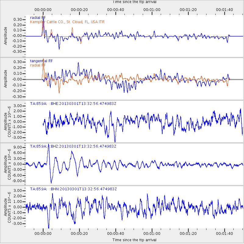
Signal To Noise
| Channel | StoN | STA | LTA |
| TA:859A: :BHZ:20130301T13:32:56.474983Z | 10.726605 | 5.0345957E-6 | 4.6935588E-7 |
| TA:859A: :BHN:20130301T13:32:56.474983Z | 2.7972002 | 1.318053E-6 | 4.7120437E-7 |
| TA:859A: :BHE:20130301T13:32:56.474983Z | 1.4296314 | 1.1208406E-6 | 7.8400666E-7 |
| Arrivals |
| Ps | 4.7 SECOND |
| PpPs | 16 SECOND |
| PsPs/PpSs | 21 SECOND |


