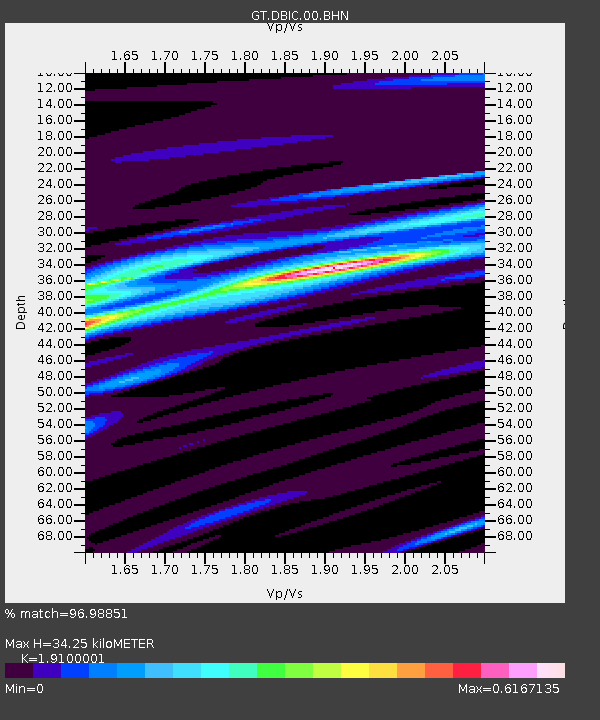
DBIC Dimbokro, Cote d'Ivoire - Earthquake Result Viewer
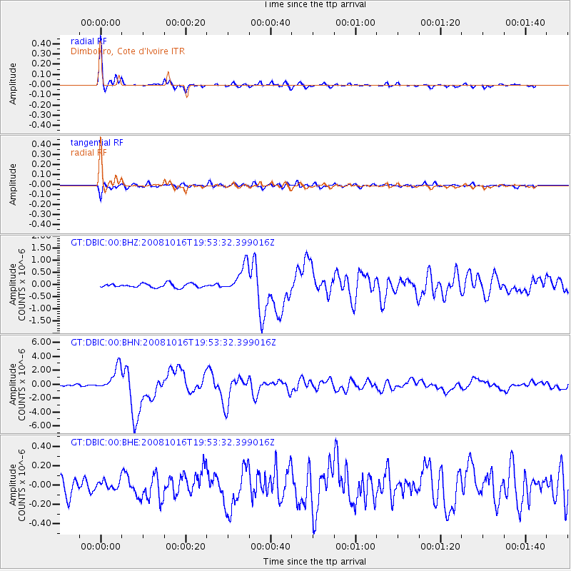
Earthquake location: Near Coast Of Chiapas, Mexico
Earthquake latitude/longitude: 14.4/-92.4
Earthquake time(UTC): 2008/10/16 (290) 19:41:25 GMT
Earthquake Depth: 24 km
Earthquake Magnitude: 6.1 MB, 6.6 MS, 6.7 MW, 6.6 MW
Earthquake Catalog/Contributor: WHDF/NEIC
Network: GT Global Telemetered Seismograph Network (USAF/USGS)
Station: DBIC Dimbokro, Cote d'Ivoire
Lat/Lon: 6.67 N/4.86 W
Elevation: 125 m
Distance: 86.0 deg
Az: 84.183 deg
Baz: 283.981 deg
Ray Param: 0.044364776
Estimated Moho Depth: 34.25 km
Estimated Crust Vp/Vs: 1.91
Assumed Crust Vp: 6.419 km/s
Estimated Crust Vs: 3.361 km/s
Estimated Crust Poisson's Ratio: 0.31
Radial Match: 96.98851 %
Radial Bump: 276
Transverse Match: 88.63518 %
Transverse Bump: 400
SOD ConfigId: 2556
Insert Time: 2010-02-27 02:00:31.228 +0000
GWidth: 2.5
Max Bumps: 400
Tol: 0.001

Signal To Noise

ChannelStoNSTALTA
GT:DBIC:00:BHN:20081016T19:53:32.399016Z17.8658541.7724618E-69.9209466E-8
GT:DBIC:00:BHE:20081016T19:53:32.399016Z0.610028864.5047592E-87.3845015E-8
GT:DBIC:00:BHZ:20081016T19:53:32.399016Z7.2062745.910426E-78.201778E-8
Arrivals
Ps5.0 SECOND
PpPs15 SECOND
PsPs/PpSs20 SECOND