You are here: Home > Network List > TA - USArray Transportable Network (new EarthScope stations) Stations List
> Station 156A Sylvania, GA, USA > Earthquake Result Viewer
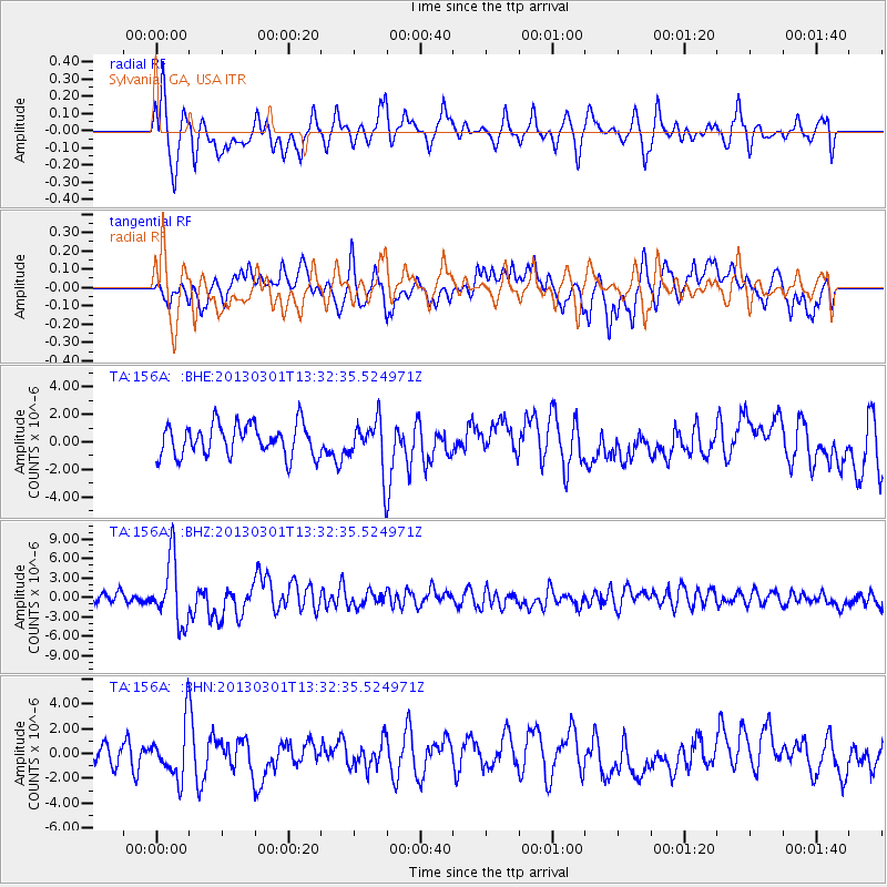
156A Sylvania, GA, USA - Earthquake Result Viewer
*The percent match for this event was below the threshold and hence no stack was calculated.
| Earthquake location: |
Kuril Islands |
| Earthquake latitude/longitude: |
51.0/157.4 |
| Earthquake time(UTC): |
2013/03/01 (060) 13:20:49 GMT |
| Earthquake Depth: |
29 km |
| Earthquake Magnitude: |
6.3 MB, 6.3 MS, 6.5 MW, 6.4 MW |
| Earthquake Catalog/Contributor: |
WHDF/NEIC |
|
| Network: |
TA USArray Transportable Network (new EarthScope stations) |
| Station: |
156A Sylvania, GA, USA |
| Lat/Lon: |
32.65 N/81.50 W |
| Elevation: |
40 m |
|
| Distance: |
81.9 deg |
| Az: |
46.851 deg |
| Baz: |
326.84 deg |
| Ray Param: |
$rayparam |
*The percent match for this event was below the threshold and hence was not used in the summary stack. |
|
| Radial Match: |
76.74903 % |
| Radial Bump: |
400 |
| Transverse Match: |
79.32577 % |
| Transverse Bump: |
400 |
| SOD ConfigId: |
494114 |
| Insert Time: |
2013-05-15 07:25:30.058 +0000 |
| GWidth: |
2.5 |
| Max Bumps: |
400 |
| Tol: |
0.001 |
|
Signal To Noise
| Channel | StoN | STA | LTA |
| TA:156A: :BHZ:20130301T13:32:35.524971Z | 8.586713 | 4.862897E-6 | 5.6632814E-7 |
| TA:156A: :BHN:20130301T13:32:35.524971Z | 2.4246602 | 2.1313072E-6 | 8.7901276E-7 |
| TA:156A: :BHE:20130301T13:32:35.524971Z | 1.5517308 | 1.7879157E-6 | 1.1522075E-6 |
| Arrivals |
| Ps | |
| PpPs | |
| PsPs/PpSs | |


