You are here: Home > Network List > TA - USArray Transportable Network (new EarthScope stations) Stations List
> Station X51A Calhoun, GA, USA > Earthquake Result Viewer
X51A Calhoun, GA, USA - Earthquake Result Viewer

| Earthquake location: |
Kuril Islands |
| Earthquake latitude/longitude: |
51.0/157.4 |
| Earthquake time(UTC): |
2013/03/01 (060) 13:20:49 GMT |
| Earthquake Depth: |
29 km |
| Earthquake Magnitude: |
6.3 MB, 6.3 MS, 6.5 MW, 6.4 MW |
| Earthquake Catalog/Contributor: |
WHDF/NEIC |
|
| Network: |
TA USArray Transportable Network (new EarthScope stations) |
| Station: |
X51A Calhoun, GA, USA |
| Lat/Lon: |
34.57 N/84.86 W |
| Elevation: |
214 m |
|
| Distance: |
78.8 deg |
| Az: |
48.131 deg |
| Baz: |
325.202 deg |
| Ray Param: |
0.049372867 |
| Estimated Moho Depth: |
35.0 km |
| Estimated Crust Vp/Vs: |
1.98 |
| Assumed Crust Vp: |
6.35 km/s |
| Estimated Crust Vs: |
3.207 km/s |
| Estimated Crust Poisson's Ratio: |
0.33 |
|
| Radial Match: |
86.74468 % |
| Radial Bump: |
304 |
| Transverse Match: |
42.917282 % |
| Transverse Bump: |
364 |
| SOD ConfigId: |
494114 |
| Insert Time: |
2013-05-15 07:25:32.712 +0000 |
| GWidth: |
2.5 |
| Max Bumps: |
400 |
| Tol: |
0.001 |
|
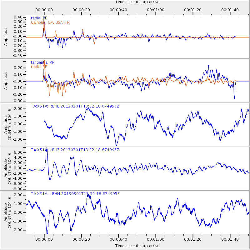
Signal To Noise
| Channel | StoN | STA | LTA |
| TA:X51A: :BHZ:20130301T13:32:18.674995Z | 6.8475614 | 3.5146666E-6 | 5.132727E-7 |
| TA:X51A: :BHN:20130301T13:32:18.674995Z | 1.4203148 | 1.020445E-6 | 7.18464E-7 |
| TA:X51A: :BHE:20130301T13:32:18.674995Z | 0.92209613 | 1.1196072E-6 | 1.2141979E-6 |
| Arrivals |
| Ps | 5.5 SECOND |
| PpPs | 16 SECOND |
| PsPs/PpSs | 22 SECOND |


