You are here: Home > Network List > TA - USArray Transportable Network (new EarthScope stations) Stations List
> Station Z51A Franklin, GA, USA > Earthquake Result Viewer
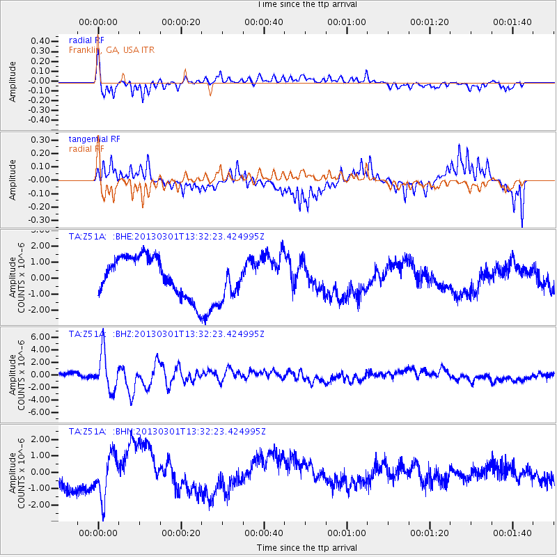
Z51A Franklin, GA, USA - Earthquake Result Viewer
*The percent match for this event was below the threshold and hence no stack was calculated.
| Earthquake location: |
Kuril Islands |
| Earthquake latitude/longitude: |
51.0/157.4 |
| Earthquake time(UTC): |
2013/03/01 (060) 13:20:49 GMT |
| Earthquake Depth: |
29 km |
| Earthquake Magnitude: |
6.3 MB, 6.3 MS, 6.5 MW, 6.4 MW |
| Earthquake Catalog/Contributor: |
WHDF/NEIC |
|
| Network: |
TA USArray Transportable Network (new EarthScope stations) |
| Station: |
Z51A Franklin, GA, USA |
| Lat/Lon: |
33.32 N/85.17 W |
| Elevation: |
249 m |
|
| Distance: |
79.7 deg |
| Az: |
49.075 deg |
| Baz: |
325.202 deg |
| Ray Param: |
$rayparam |
*The percent match for this event was below the threshold and hence was not used in the summary stack. |
|
| Radial Match: |
71.17903 % |
| Radial Bump: |
400 |
| Transverse Match: |
55.302483 % |
| Transverse Bump: |
363 |
| SOD ConfigId: |
494114 |
| Insert Time: |
2013-05-15 07:25:52.288 +0000 |
| GWidth: |
2.5 |
| Max Bumps: |
400 |
| Tol: |
0.001 |
|
Signal To Noise
| Channel | StoN | STA | LTA |
| TA:Z51A: :BHZ:20130301T13:32:23.424995Z | 7.2053714 | 3.019004E-6 | 4.1899352E-7 |
| TA:Z51A: :BHN:20130301T13:32:23.424995Z | 1.9456122 | 1.3249155E-6 | 6.8097614E-7 |
| TA:Z51A: :BHE:20130301T13:32:23.424995Z | 0.94690144 | 1.1444971E-6 | 1.208676E-6 |
| Arrivals |
| Ps | |
| PpPs | |
| PsPs/PpSs | |


