You are here: Home > Network List > TA - USArray Transportable Network (new EarthScope stations) Stations List
> Station W52A Murphy, NC, USA > Earthquake Result Viewer
W52A Murphy, NC, USA - Earthquake Result Viewer
| Earthquake location: |
Kuril Islands |
| Earthquake latitude/longitude: |
51.0/157.4 |
| Earthquake time(UTC): |
2013/03/01 (060) 13:20:49 GMT |
| Earthquake Depth: |
29 km |
| Earthquake Magnitude: |
6.3 MB, 6.3 MS, 6.5 MW, 6.4 MW |
| Earthquake Catalog/Contributor: |
WHDF/NEIC |
|
| Network: |
TA USArray Transportable Network (new EarthScope stations) |
| Station: |
W52A Murphy, NC, USA |
| Lat/Lon: |
35.09 N/83.93 W |
| Elevation: |
519 m |
|
| Distance: |
78.8 deg |
| Az: |
47.184 deg |
| Baz: |
325.546 deg |
| Ray Param: |
0.04937193 |
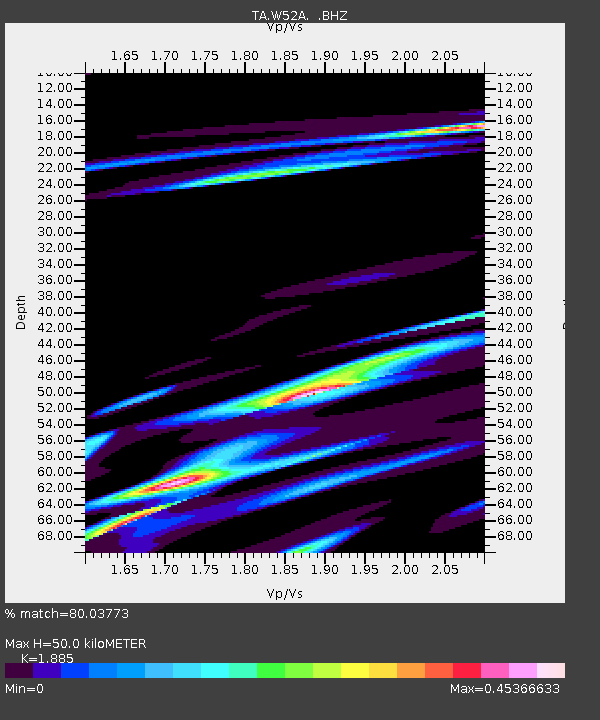
| Estimated Moho Depth: |
50.0 km |
| Estimated Crust Vp/Vs: |
1.88 |
| Assumed Crust Vp: |
6.35 km/s |
| Estimated Crust Vs: |
3.369 km/s |
| Estimated Crust Poisson's Ratio: |
0.30 |
|
| Radial Match: |
80.03773 % |
| Radial Bump: |
393 |
| Transverse Match: |
40.816055 % |
| Transverse Bump: |
330 |
| SOD ConfigId: |
494114 |
| Insert Time: |
2013-05-15 07:26:21.246 +0000 |
| GWidth: |
2.5 |
| Max Bumps: |
400 |
| Tol: |
0.001 |
|
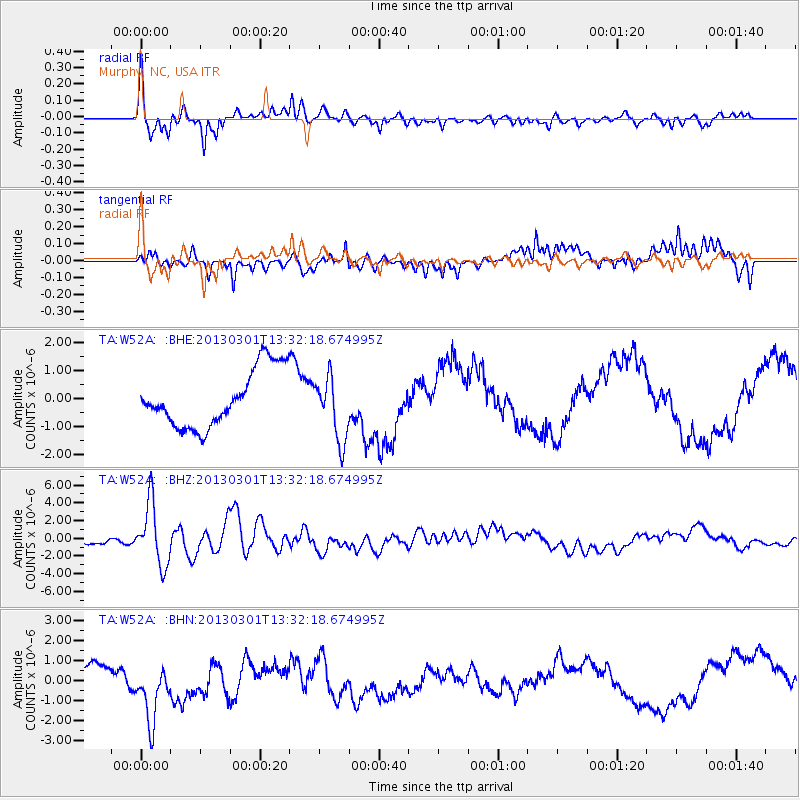
Signal To Noise
| Channel | StoN | STA | LTA |
| TA:W52A: :BHZ:20130301T13:32:18.674995Z | 5.861203 | 3.494973E-6 | 5.9628934E-7 |
| TA:W52A: :BHN:20130301T13:32:18.674995Z | 3.412288 | 1.5012633E-6 | 4.39958E-7 |
| TA:W52A: :BHE:20130301T13:32:18.674995Z | 1.1305712 | 1.140808E-6 | 1.0090545E-6 |
| Arrivals |
| Ps | 7.2 SECOND |
| PpPs | 22 SECOND |
| PsPs/PpSs | 29 SECOND |


