You are here: Home > Network List > TA - USArray Transportable Network (new EarthScope stations) Stations List
> Station W49A Belvidere, TN, USA > Earthquake Result Viewer
W49A Belvidere, TN, USA - Earthquake Result Viewer
| Earthquake location: |
Kuril Islands |
| Earthquake latitude/longitude: |
51.0/157.4 |
| Earthquake time(UTC): |
2013/03/01 (060) 13:20:49 GMT |
| Earthquake Depth: |
29 km |
| Earthquake Magnitude: |
6.3 MB, 6.3 MS, 6.5 MW, 6.4 MW |
| Earthquake Catalog/Contributor: |
WHDF/NEIC |
|
| Network: |
TA USArray Transportable Network (new EarthScope stations) |
| Station: |
W49A Belvidere, TN, USA |
| Lat/Lon: |
35.12 N/86.26 W |
| Elevation: |
251 m |
|
| Distance: |
77.7 deg |
| Az: |
48.773 deg |
| Baz: |
324.532 deg |
| Ray Param: |
0.05013234 |
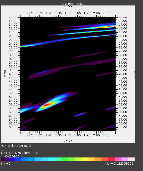
| Estimated Moho Depth: |
14.75 km |
| Estimated Crust Vp/Vs: |
2.09 |
| Assumed Crust Vp: |
6.476 km/s |
| Estimated Crust Vs: |
3.095 km/s |
| Estimated Crust Poisson's Ratio: |
0.35 |
|
| Radial Match: |
83.64673 % |
| Radial Bump: |
315 |
| Transverse Match: |
12.558025 % |
| Transverse Bump: |
277 |
| SOD ConfigId: |
494114 |
| Insert Time: |
2013-05-15 07:26:23.178 +0000 |
| GWidth: |
2.5 |
| Max Bumps: |
400 |
| Tol: |
0.001 |
|
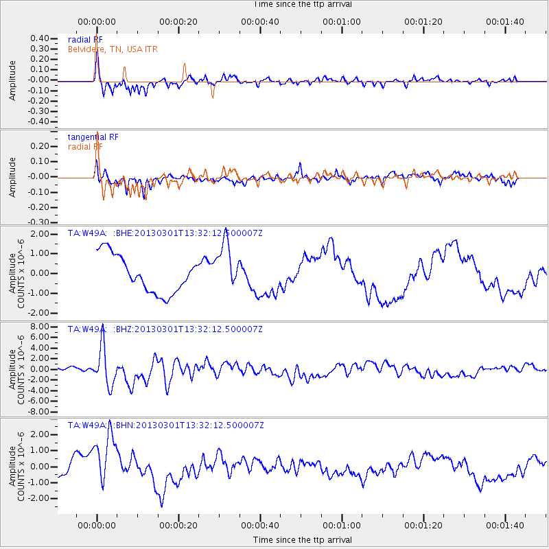
Signal To Noise
| Channel | StoN | STA | LTA |
| TA:W49A: :BHZ:20130301T13:32:12.500007Z | 8.670731 | 3.7111142E-6 | 4.2800477E-7 |
| TA:W49A: :BHN:20130301T13:32:12.500007Z | 2.2554557 | 1.7281976E-6 | 7.6622996E-7 |
| TA:W49A: :BHE:20130301T13:32:12.500007Z | 1.3226902 | 1.2375573E-6 | 9.3563654E-7 |
| Arrivals |
| Ps | 2.6 SECOND |
| PpPs | 6.9 SECOND |
| PsPs/PpSs | 9.4 SECOND |


