You are here: Home > Network List > TA - USArray Transportable Network (new EarthScope stations) Stations List
> Station T51A Gray, KY, USA > Earthquake Result Viewer
T51A Gray, KY, USA - Earthquake Result Viewer
| Earthquake location: |
Kuril Islands |
| Earthquake latitude/longitude: |
51.0/157.4 |
| Earthquake time(UTC): |
2013/03/01 (060) 13:20:49 GMT |
| Earthquake Depth: |
29 km |
| Earthquake Magnitude: |
6.3 MB, 6.3 MS, 6.5 MW, 6.4 MW |
| Earthquake Catalog/Contributor: |
WHDF/NEIC |
|
| Network: |
TA USArray Transportable Network (new EarthScope stations) |
| Station: |
T51A Gray, KY, USA |
| Lat/Lon: |
36.97 N/83.95 W |
| Elevation: |
329 m |
|
| Distance: |
77.2 deg |
| Az: |
46.113 deg |
| Baz: |
325.313 deg |
| Ray Param: |
0.050422605 |
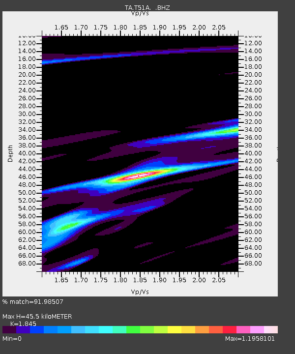
| Estimated Moho Depth: |
45.5 km |
| Estimated Crust Vp/Vs: |
1.85 |
| Assumed Crust Vp: |
6.476 km/s |
| Estimated Crust Vs: |
3.51 km/s |
| Estimated Crust Poisson's Ratio: |
0.29 |
|
| Radial Match: |
91.98507 % |
| Radial Bump: |
299 |
| Transverse Match: |
68.05841 % |
| Transverse Bump: |
362 |
| SOD ConfigId: |
494114 |
| Insert Time: |
2013-05-15 07:27:53.169 +0000 |
| GWidth: |
2.5 |
| Max Bumps: |
400 |
| Tol: |
0.001 |
|
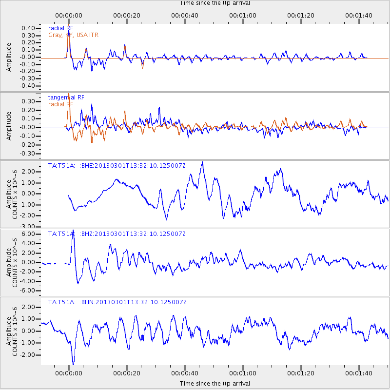
Signal To Noise
| Channel | StoN | STA | LTA |
| TA:T51A: :BHZ:20130301T13:32:10.125007Z | 9.795779 | 3.2243918E-6 | 3.2916134E-7 |
| TA:T51A: :BHN:20130301T13:32:10.125007Z | 2.2775826 | 1.2580387E-6 | 5.52357E-7 |
| TA:T51A: :BHE:20130301T13:32:10.125007Z | 1.5657903 | 1.3224169E-6 | 8.445683E-7 |
| Arrivals |
| Ps | 6.1 SECOND |
| PpPs | 19 SECOND |
| PsPs/PpSs | 26 SECOND |


