You are here: Home > Network List > TA - USArray Transportable Network (new EarthScope stations) Stations List
> Station P50A Jamestown, OH, USA > Earthquake Result Viewer
P50A Jamestown, OH, USA - Earthquake Result Viewer
| Earthquake location: |
Kuril Islands |
| Earthquake latitude/longitude: |
51.0/157.4 |
| Earthquake time(UTC): |
2013/03/01 (060) 13:20:49 GMT |
| Earthquake Depth: |
29 km |
| Earthquake Magnitude: |
6.3 MB, 6.3 MS, 6.5 MW, 6.4 MW |
| Earthquake Catalog/Contributor: |
WHDF/NEIC |
|
| Network: |
TA USArray Transportable Network (new EarthScope stations) |
| Station: |
P50A Jamestown, OH, USA |
| Lat/Lon: |
39.61 N/83.80 W |
| Elevation: |
318 m |
|
| Distance: |
75.1 deg |
| Az: |
44.463 deg |
| Baz: |
325.009 deg |
| Ray Param: |
0.0518328 |
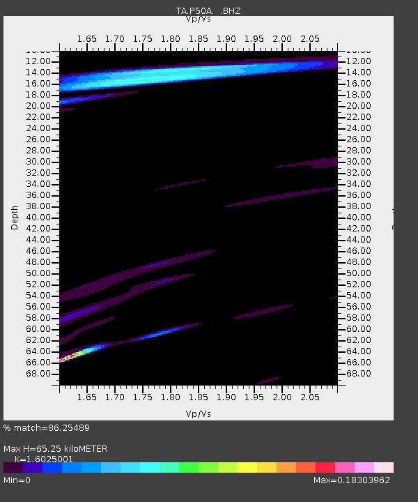
| Estimated Moho Depth: |
65.25 km |
| Estimated Crust Vp/Vs: |
1.60 |
| Assumed Crust Vp: |
6.232 km/s |
| Estimated Crust Vs: |
3.889 km/s |
| Estimated Crust Poisson's Ratio: |
0.18 |
|
| Radial Match: |
86.25489 % |
| Radial Bump: |
400 |
| Transverse Match: |
69.19067 % |
| Transverse Bump: |
400 |
| SOD ConfigId: |
494114 |
| Insert Time: |
2013-05-15 07:28:33.933 +0000 |
| GWidth: |
2.5 |
| Max Bumps: |
400 |
| Tol: |
0.001 |
|

Signal To Noise
| Channel | StoN | STA | LTA |
| TA:P50A: :BHZ:20130301T13:31:58.224983Z | 11.092003 | 3.6101787E-6 | 3.2547584E-7 |
| TA:P50A: :BHN:20130301T13:31:58.224983Z | 5.2118893 | 1.197033E-6 | 2.2967353E-7 |
| TA:P50A: :BHE:20130301T13:31:58.224983Z | 2.163165 | 9.4013495E-7 | 4.346108E-7 |
| Arrivals |
| Ps | 6.5 SECOND |
| PpPs | 26 SECOND |
| PsPs/PpSs | 33 SECOND |


