You are here: Home > Network List > TA - USArray Transportable Network (new EarthScope stations) Stations List
> Station P48A Milroy, IN, USA > Earthquake Result Viewer
P48A Milroy, IN, USA - Earthquake Result Viewer

| Earthquake location: |
Kuril Islands |
| Earthquake latitude/longitude: |
51.0/157.4 |
| Earthquake time(UTC): |
2013/03/01 (060) 13:20:49 GMT |
| Earthquake Depth: |
29 km |
| Earthquake Magnitude: |
6.3 MB, 6.3 MS, 6.5 MW, 6.4 MW |
| Earthquake Catalog/Contributor: |
WHDF/NEIC |
|
| Network: |
TA USArray Transportable Network (new EarthScope stations) |
| Station: |
P48A Milroy, IN, USA |
| Lat/Lon: |
39.46 N/85.43 W |
| Elevation: |
300 m |
|
| Distance: |
74.5 deg |
| Az: |
45.615 deg |
| Baz: |
324.279 deg |
| Ray Param: |
0.052234642 |
| Estimated Moho Depth: |
34.25 km |
| Estimated Crust Vp/Vs: |
1.96 |
| Assumed Crust Vp: |
6.498 km/s |
| Estimated Crust Vs: |
3.324 km/s |
| Estimated Crust Poisson's Ratio: |
0.32 |
|
| Radial Match: |
87.487755 % |
| Radial Bump: |
400 |
| Transverse Match: |
55.53325 % |
| Transverse Bump: |
354 |
| SOD ConfigId: |
494114 |
| Insert Time: |
2013-05-15 07:29:17.178 +0000 |
| GWidth: |
2.5 |
| Max Bumps: |
400 |
| Tol: |
0.001 |
|
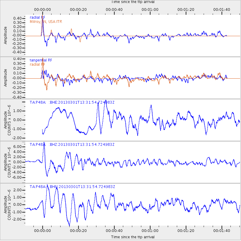
Signal To Noise
| Channel | StoN | STA | LTA |
| TA:P48A: :BHZ:20130301T13:31:54.724983Z | 6.3347645 | 3.587275E-6 | 5.662839E-7 |
| TA:P48A: :BHN:20130301T13:31:54.724983Z | 3.5479004 | 1.4656434E-6 | 4.1310162E-7 |
| TA:P48A: :BHE:20130301T13:31:54.724983Z | 1.044726 | 1.0677453E-6 | 1.0220338E-6 |
| Arrivals |
| Ps | 5.2 SECOND |
| PpPs | 15 SECOND |
| PsPs/PpSs | 20 SECOND |


