You are here: Home > Network List > TA - USArray Transportable Network (new EarthScope stations) Stations List
> Station L46A Eue Claire, MI, USA > Earthquake Result Viewer
L46A Eue Claire, MI, USA - Earthquake Result Viewer
| Earthquake location: |
Kuril Islands |
| Earthquake latitude/longitude: |
51.0/157.4 |
| Earthquake time(UTC): |
2013/03/01 (060) 13:20:49 GMT |
| Earthquake Depth: |
29 km |
| Earthquake Magnitude: |
6.3 MB, 6.3 MS, 6.5 MW, 6.4 MW |
| Earthquake Catalog/Contributor: |
WHDF/NEIC |
|
| Network: |
TA USArray Transportable Network (new EarthScope stations) |
| Station: |
L46A Eue Claire, MI, USA |
| Lat/Lon: |
42.01 N/86.30 W |
| Elevation: |
223 m |
|
| Distance: |
72.1 deg |
| Az: |
44.602 deg |
| Baz: |
323.423 deg |
| Ray Param: |
0.053860113 |
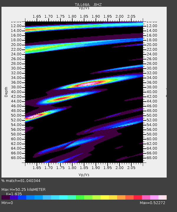
| Estimated Moho Depth: |
50.25 km |
| Estimated Crust Vp/Vs: |
1.63 |
| Assumed Crust Vp: |
6.483 km/s |
| Estimated Crust Vs: |
3.965 km/s |
| Estimated Crust Poisson's Ratio: |
0.20 |
|
| Radial Match: |
81.040344 % |
| Radial Bump: |
400 |
| Transverse Match: |
72.15036 % |
| Transverse Bump: |
400 |
| SOD ConfigId: |
494114 |
| Insert Time: |
2013-05-15 07:31:35.219 +0000 |
| GWidth: |
2.5 |
| Max Bumps: |
400 |
| Tol: |
0.001 |
|
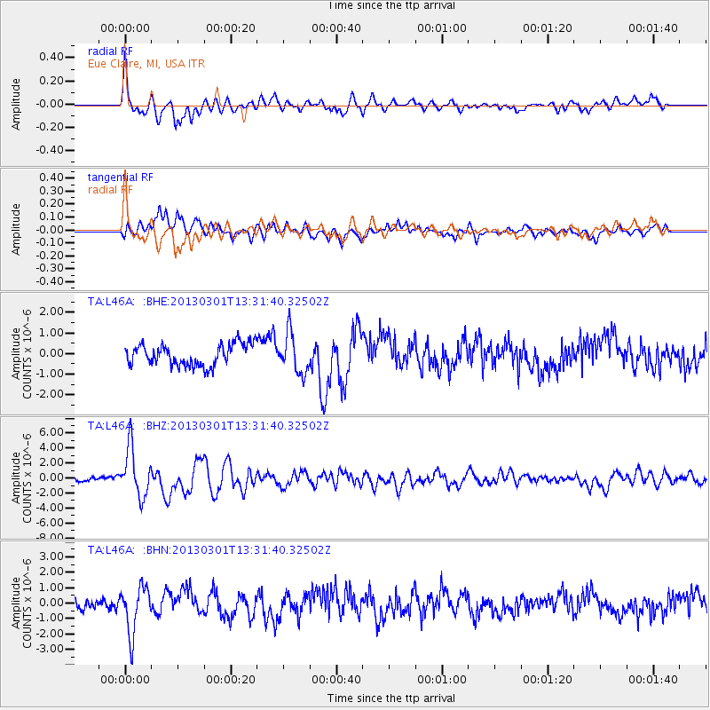
Signal To Noise
| Channel | StoN | STA | LTA |
| TA:L46A: :BHZ:20130301T13:31:40.32502Z | 8.038976 | 3.309688E-6 | 4.117052E-7 |
| TA:L46A: :BHN:20130301T13:31:40.32502Z | 4.2393055 | 1.5422952E-6 | 3.6380845E-7 |
| TA:L46A: :BHE:20130301T13:31:40.32502Z | 1.8513246 | 9.619437E-7 | 5.195975E-7 |
| Arrivals |
| Ps | 5.1 SECOND |
| PpPs | 20 SECOND |
| PsPs/PpSs | 25 SECOND |


