You are here: Home > Network List > TA - USArray Transportable Network (new EarthScope stations) Stations List
> Station D46A Sault St. Marie, ON, CAN > Earthquake Result Viewer
D46A Sault St. Marie, ON, CAN - Earthquake Result Viewer
| Earthquake location: |
Kuril Islands |
| Earthquake latitude/longitude: |
51.0/157.4 |
| Earthquake time(UTC): |
2013/03/01 (060) 13:20:49 GMT |
| Earthquake Depth: |
29 km |
| Earthquake Magnitude: |
6.3 MB, 6.3 MS, 6.5 MW, 6.4 MW |
| Earthquake Catalog/Contributor: |
WHDF/NEIC |
|
| Network: |
TA USArray Transportable Network (new EarthScope stations) |
| Station: |
D46A Sault St. Marie, ON, CAN |
| Lat/Lon: |
46.89 N/84.04 W |
| Elevation: |
353 m |
|
| Distance: |
69.1 deg |
| Az: |
40.146 deg |
| Baz: |
323.52 deg |
| Ray Param: |
0.055815686 |
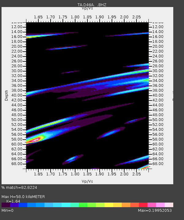
| Estimated Moho Depth: |
58.0 km |
| Estimated Crust Vp/Vs: |
1.64 |
| Assumed Crust Vp: |
6.467 km/s |
| Estimated Crust Vs: |
3.943 km/s |
| Estimated Crust Poisson's Ratio: |
0.20 |
|
| Radial Match: |
82.8224 % |
| Radial Bump: |
400 |
| Transverse Match: |
59.941505 % |
| Transverse Bump: |
366 |
| SOD ConfigId: |
494114 |
| Insert Time: |
2013-05-15 07:33:08.618 +0000 |
| GWidth: |
2.5 |
| Max Bumps: |
400 |
| Tol: |
0.001 |
|

Signal To Noise
| Channel | StoN | STA | LTA |
| TA:D46A: :BHZ:20130301T13:31:22.349983Z | 4.563292 | 2.1959565E-6 | 4.81222E-7 |
| TA:D46A: :BHN:20130301T13:31:22.349983Z | 2.068653 | 9.532358E-7 | 4.6080024E-7 |
| TA:D46A: :BHE:20130301T13:31:22.349983Z | 1.0287852 | 3.8132833E-7 | 3.7065885E-7 |
| Arrivals |
| Ps | 6.0 SECOND |
| PpPs | 23 SECOND |
| PsPs/PpSs | 29 SECOND |


