You are here: Home > Network List > TA - USArray Transportable Network (new EarthScope stations) Stations List
> Station H48A Harrisville, MI, USA > Earthquake Result Viewer
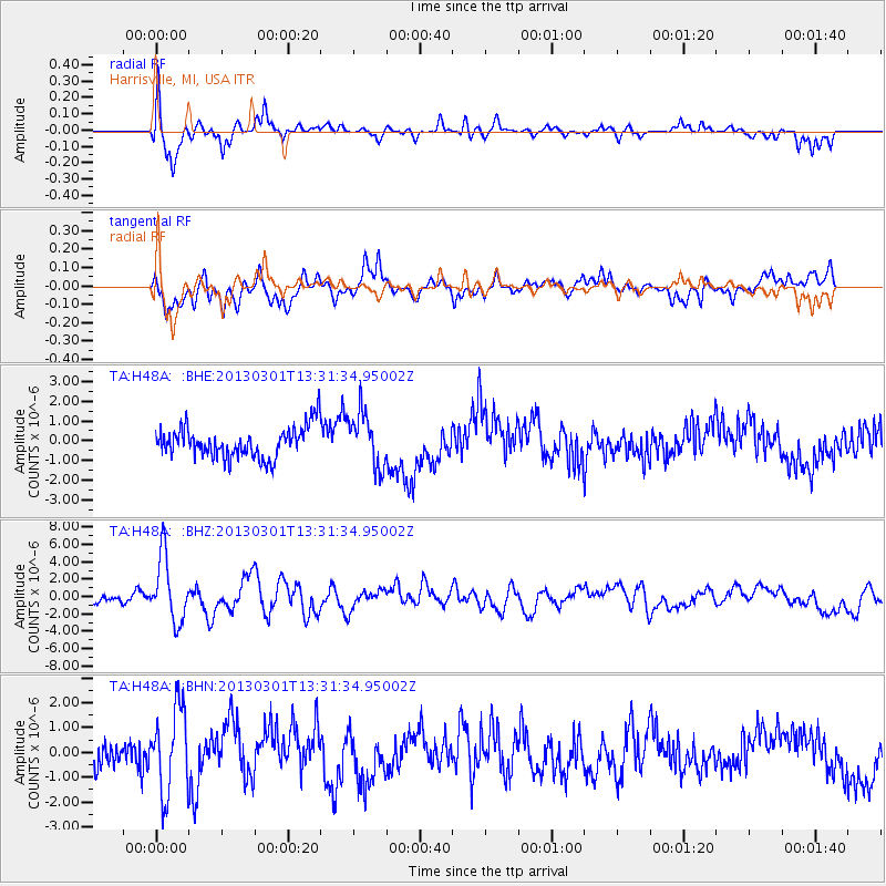
H48A Harrisville, MI, USA - Earthquake Result Viewer
*The percent match for this event was below the threshold and hence no stack was calculated.
| Earthquake location: |
Kuril Islands |
| Earthquake latitude/longitude: |
51.0/157.4 |
| Earthquake time(UTC): |
2013/03/01 (060) 13:20:49 GMT |
| Earthquake Depth: |
29 km |
| Earthquake Magnitude: |
6.3 MB, 6.3 MS, 6.5 MW, 6.4 MW |
| Earthquake Catalog/Contributor: |
WHDF/NEIC |
|
| Network: |
TA USArray Transportable Network (new EarthScope stations) |
| Station: |
H48A Harrisville, MI, USA |
| Lat/Lon: |
44.70 N/83.32 W |
| Elevation: |
244 m |
|
| Distance: |
71.2 deg |
| Az: |
41.089 deg |
| Baz: |
324.348 deg |
| Ray Param: |
$rayparam |
*The percent match for this event was below the threshold and hence was not used in the summary stack. |
|
| Radial Match: |
73.37421 % |
| Radial Bump: |
400 |
| Transverse Match: |
59.455627 % |
| Transverse Bump: |
400 |
| SOD ConfigId: |
494114 |
| Insert Time: |
2013-05-15 07:33:56.262 +0000 |
| GWidth: |
2.5 |
| Max Bumps: |
400 |
| Tol: |
0.001 |
|
Signal To Noise
| Channel | StoN | STA | LTA |
| TA:H48A: :BHZ:20130301T13:31:34.95002Z | 6.372805 | 3.722213E-6 | 5.8407767E-7 |
| TA:H48A: :BHN:20130301T13:31:34.95002Z | 2.2468195 | 1.704645E-6 | 7.5869247E-7 |
| TA:H48A: :BHE:20130301T13:31:34.95002Z | 1.7408637 | 1.3665882E-6 | 7.8500585E-7 |
| Arrivals |
| Ps | |
| PpPs | |
| PsPs/PpSs | |


