You are here: Home > Network List > TA - USArray Transportable Network (new EarthScope stations) Stations List
> Station G46A Petoskey, MI, USA > Earthquake Result Viewer
G46A Petoskey, MI, USA - Earthquake Result Viewer
| Earthquake location: |
Kuril Islands |
| Earthquake latitude/longitude: |
51.0/157.4 |
| Earthquake time(UTC): |
2013/03/01 (060) 13:20:49 GMT |
| Earthquake Depth: |
29 km |
| Earthquake Magnitude: |
6.3 MB, 6.3 MS, 6.5 MW, 6.4 MW |
| Earthquake Catalog/Contributor: |
WHDF/NEIC |
|
| Network: |
TA USArray Transportable Network (new EarthScope stations) |
| Station: |
G46A Petoskey, MI, USA |
| Lat/Lon: |
45.32 N/84.86 W |
| Elevation: |
239 m |
|
| Distance: |
70.0 deg |
| Az: |
41.638 deg |
| Baz: |
323.447 deg |
| Ray Param: |
0.05520312 |
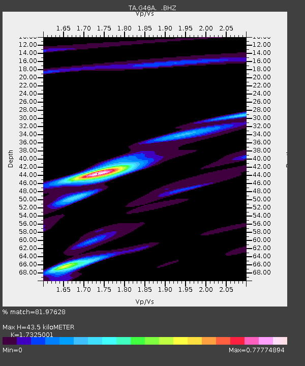
| Estimated Moho Depth: |
43.5 km |
| Estimated Crust Vp/Vs: |
1.73 |
| Assumed Crust Vp: |
6.483 km/s |
| Estimated Crust Vs: |
3.742 km/s |
| Estimated Crust Poisson's Ratio: |
0.25 |
|
| Radial Match: |
81.97628 % |
| Radial Bump: |
400 |
| Transverse Match: |
62.744648 % |
| Transverse Bump: |
399 |
| SOD ConfigId: |
494114 |
| Insert Time: |
2013-05-15 07:35:16.570 +0000 |
| GWidth: |
2.5 |
| Max Bumps: |
400 |
| Tol: |
0.001 |
|

Signal To Noise
| Channel | StoN | STA | LTA |
| TA:G46A: :BHZ:20130301T13:31:28.024971Z | 7.1962314 | 3.9951306E-6 | 5.5516983E-7 |
| TA:G46A: :BHN:20130301T13:31:28.024971Z | 3.1763935 | 1.6448425E-6 | 5.1783337E-7 |
| TA:G46A: :BHE:20130301T13:31:28.024971Z | 1.5722291 | 1.5636193E-6 | 9.945238E-7 |
| Arrivals |
| Ps | 5.1 SECOND |
| PpPs | 18 SECOND |
| PsPs/PpSs | 23 SECOND |


