You are here: Home > Network List > TA - USArray Transportable Network (new EarthScope stations) Stations List
> Station G53A Haliburton, ON, CAN > Earthquake Result Viewer
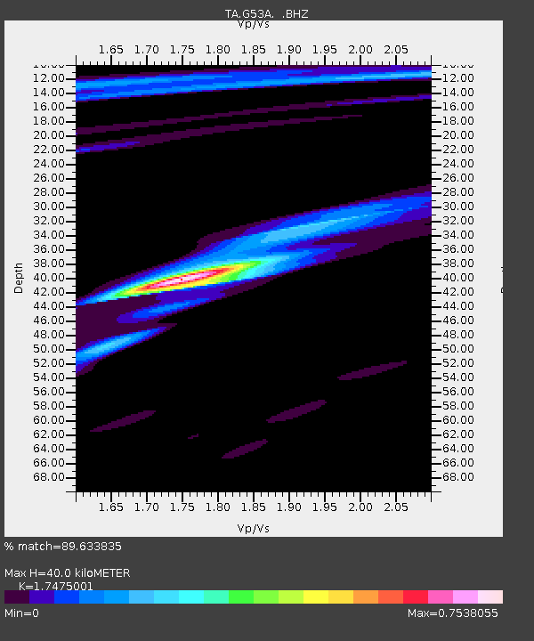
G53A Haliburton, ON, CAN - Earthquake Result Viewer
| Earthquake location: |
Kuril Islands |
| Earthquake latitude/longitude: |
51.0/157.4 |
| Earthquake time(UTC): |
2013/03/01 (060) 13:20:49 GMT |
| Earthquake Depth: |
29 km |
| Earthquake Magnitude: |
6.3 MB, 6.3 MS, 6.5 MW, 6.4 MW |
| Earthquake Catalog/Contributor: |
WHDF/NEIC |
|
| Network: |
TA USArray Transportable Network (new EarthScope stations) |
| Station: |
G53A Haliburton, ON, CAN |
| Lat/Lon: |
45.12 N/78.62 W |
| Elevation: |
333 m |
|
| Distance: |
72.7 deg |
| Az: |
37.943 deg |
| Baz: |
326.683 deg |
| Ray Param: |
0.053429965 |
| Estimated Moho Depth: |
40.0 km |
| Estimated Crust Vp/Vs: |
1.75 |
| Assumed Crust Vp: |
6.577 km/s |
| Estimated Crust Vs: |
3.764 km/s |
| Estimated Crust Poisson's Ratio: |
0.26 |
|
| Radial Match: |
89.633835 % |
| Radial Bump: |
276 |
| Transverse Match: |
71.9796 % |
| Transverse Bump: |
400 |
| SOD ConfigId: |
494114 |
| Insert Time: |
2013-05-15 07:35:53.276 +0000 |
| GWidth: |
2.5 |
| Max Bumps: |
400 |
| Tol: |
0.001 |
|

Signal To Noise
| Channel | StoN | STA | LTA |
| TA:G53A: :BHZ:20130301T13:31:44.20002Z | 5.6952376 | 3.1459829E-6 | 5.5238837E-7 |
| TA:G53A: :BHN:20130301T13:31:44.20002Z | 2.0726647 | 1.3766969E-6 | 6.6421586E-7 |
| TA:G53A: :BHE:20130301T13:31:44.20002Z | 2.1696064 | 1.1545908E-6 | 5.3216604E-7 |
| Arrivals |
| Ps | 4.7 SECOND |
| PpPs | 16 SECOND |
| PsPs/PpSs | 21 SECOND |


