You are here: Home > Network List > TA - USArray Transportable Network (new EarthScope stations) Stations List
> Station L50A Kingsville, ON, CAN > Earthquake Result Viewer
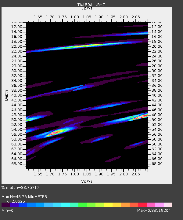
L50A Kingsville, ON, CAN - Earthquake Result Viewer
| Earthquake location: |
Kuril Islands |
| Earthquake latitude/longitude: |
51.0/157.4 |
| Earthquake time(UTC): |
2013/03/01 (060) 13:20:49 GMT |
| Earthquake Depth: |
29 km |
| Earthquake Magnitude: |
6.3 MB, 6.3 MS, 6.5 MW, 6.4 MW |
| Earthquake Catalog/Contributor: |
WHDF/NEIC |
|
| Network: |
TA USArray Transportable Network (new EarthScope stations) |
| Station: |
L50A Kingsville, ON, CAN |
| Lat/Lon: |
42.04 N/82.81 W |
| Elevation: |
187 m |
|
| Distance: |
73.6 deg |
| Az: |
42.377 deg |
| Baz: |
325.091 deg |
| Ray Param: |
0.05287626 |
| Estimated Moho Depth: |
48.75 km |
| Estimated Crust Vp/Vs: |
2.06 |
| Assumed Crust Vp: |
6.483 km/s |
| Estimated Crust Vs: |
3.143 km/s |
| Estimated Crust Poisson's Ratio: |
0.35 |
|
| Radial Match: |
83.75717 % |
| Radial Bump: |
400 |
| Transverse Match: |
70.18306 % |
| Transverse Bump: |
397 |
| SOD ConfigId: |
494114 |
| Insert Time: |
2013-05-15 07:36:26.049 +0000 |
| GWidth: |
2.5 |
| Max Bumps: |
400 |
| Tol: |
0.001 |
|

Signal To Noise
| Channel | StoN | STA | LTA |
| TA:L50A: :BHZ:20130301T13:31:49.149971Z | 7.728161 | 3.4119937E-6 | 4.4150136E-7 |
| TA:L50A: :BHN:20130301T13:31:49.149971Z | 3.6810098 | 1.4086822E-6 | 3.8268908E-7 |
| TA:L50A: :BHE:20130301T13:31:49.149971Z | 0.9452313 | 8.083408E-7 | 8.551778E-7 |
| Arrivals |
| Ps | 8.2 SECOND |
| PpPs | 22 SECOND |
| PsPs/PpSs | 31 SECOND |


