You are here: Home > Network List > TA - USArray Transportable Network (new EarthScope stations) Stations List
> Station N52A McGinn's Farm, Dalton, OH, USA > Earthquake Result Viewer
N52A McGinn's Farm, Dalton, OH, USA - Earthquake Result Viewer
| Earthquake location: |
Kuril Islands |
| Earthquake latitude/longitude: |
51.0/157.4 |
| Earthquake time(UTC): |
2013/03/01 (060) 13:20:49 GMT |
| Earthquake Depth: |
29 km |
| Earthquake Magnitude: |
6.3 MB, 6.3 MS, 6.5 MW, 6.4 MW |
| Earthquake Catalog/Contributor: |
WHDF/NEIC |
|
| Network: |
TA USArray Transportable Network (new EarthScope stations) |
| Station: |
N52A McGinn's Farm, Dalton, OH, USA |
| Lat/Lon: |
40.81 N/81.69 W |
| Elevation: |
331 m |
|
| Distance: |
75.1 deg |
| Az: |
42.378 deg |
| Baz: |
325.832 deg |
| Ray Param: |
0.051879033 |
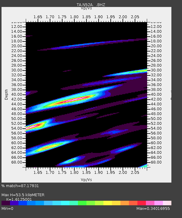
| Estimated Moho Depth: |
53.5 km |
| Estimated Crust Vp/Vs: |
1.61 |
| Assumed Crust Vp: |
6.483 km/s |
| Estimated Crust Vs: |
4.02 km/s |
| Estimated Crust Poisson's Ratio: |
0.19 |
|
| Radial Match: |
87.17931 % |
| Radial Bump: |
327 |
| Transverse Match: |
75.96285 % |
| Transverse Bump: |
331 |
| SOD ConfigId: |
494114 |
| Insert Time: |
2013-05-15 07:37:26.390 +0000 |
| GWidth: |
2.5 |
| Max Bumps: |
400 |
| Tol: |
0.001 |
|

Signal To Noise
| Channel | StoN | STA | LTA |
| TA:N52A: :BHZ:20130301T13:31:57.82502Z | 11.320956 | 3.6757194E-6 | 3.246828E-7 |
| TA:N52A: :BHN:20130301T13:31:57.82502Z | 4.1310277 | 1.6614938E-6 | 4.0219862E-7 |
| TA:N52A: :BHE:20130301T13:31:57.82502Z | 2.2261343 | 1.5932603E-6 | 7.157072E-7 |
| Arrivals |
| Ps | 5.2 SECOND |
| PpPs | 21 SECOND |
| PsPs/PpSs | 26 SECOND |


