You are here: Home > Network List > TA - USArray Transportable Network (new EarthScope stations) Stations List
> Station T54A Tazewell, VA, USA > Earthquake Result Viewer
T54A Tazewell, VA, USA - Earthquake Result Viewer
| Earthquake location: |
Kuril Islands |
| Earthquake latitude/longitude: |
51.0/157.4 |
| Earthquake time(UTC): |
2013/03/01 (060) 13:20:49 GMT |
| Earthquake Depth: |
29 km |
| Earthquake Magnitude: |
6.3 MB, 6.3 MS, 6.5 MW, 6.4 MW |
| Earthquake Catalog/Contributor: |
WHDF/NEIC |
|
| Network: |
TA USArray Transportable Network (new EarthScope stations) |
| Station: |
T54A Tazewell, VA, USA |
| Lat/Lon: |
37.06 N/81.58 W |
| Elevation: |
852 m |
|
| Distance: |
78.2 deg |
| Az: |
44.452 deg |
| Baz: |
326.38 deg |
| Ray Param: |
0.049752135 |
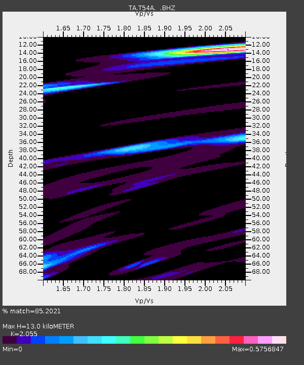
| Estimated Moho Depth: |
13.0 km |
| Estimated Crust Vp/Vs: |
2.06 |
| Assumed Crust Vp: |
6.159 km/s |
| Estimated Crust Vs: |
2.997 km/s |
| Estimated Crust Poisson's Ratio: |
0.34 |
|
| Radial Match: |
85.2021 % |
| Radial Bump: |
338 |
| Transverse Match: |
54.60545 % |
| Transverse Bump: |
363 |
| SOD ConfigId: |
494114 |
| Insert Time: |
2013-05-15 07:38:21.645 +0000 |
| GWidth: |
2.5 |
| Max Bumps: |
400 |
| Tol: |
0.001 |
|
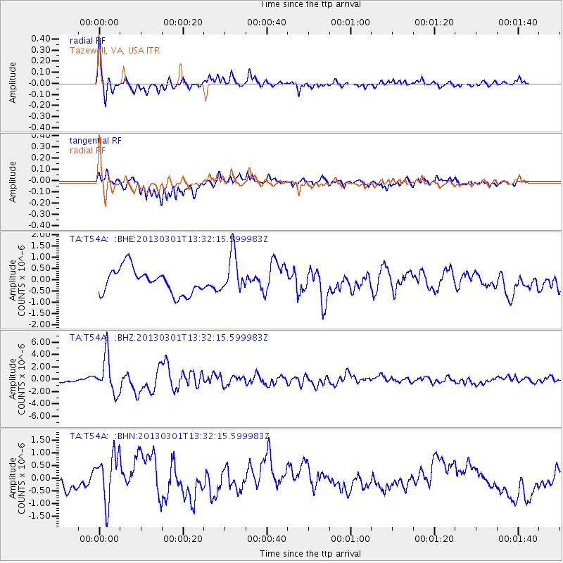
Signal To Noise
| Channel | StoN | STA | LTA |
| TA:T54A: :BHZ:20130301T13:32:15.599983Z | 8.818655 | 3.090904E-6 | 3.5049607E-7 |
| TA:T54A: :BHN:20130301T13:32:15.599983Z | 2.4305966 | 9.63074E-7 | 3.9622944E-7 |
| TA:T54A: :BHE:20130301T13:32:15.599983Z | 1.6348153 | 8.996704E-7 | 5.503193E-7 |
| Arrivals |
| Ps | 2.3 SECOND |
| PpPs | 6.3 SECOND |
| PsPs/PpSs | 8.6 SECOND |


