You are here: Home > Network List > TA - USArray Transportable Network (new EarthScope stations) Stations List
> Station A21K Barrow, AK, USA > Earthquake Result Viewer
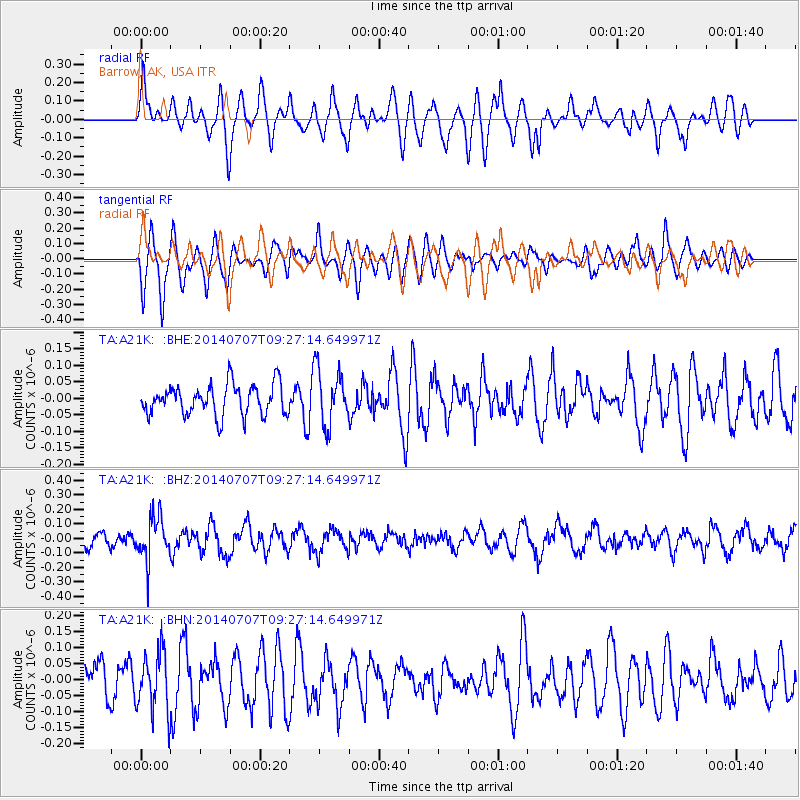
A21K Barrow, AK, USA - Earthquake Result Viewer
*The percent match for this event was below the threshold and hence no stack was calculated.
| Earthquake location: |
Banda Sea |
| Earthquake latitude/longitude: |
-7.3/123.7 |
| Earthquake time(UTC): |
2014/07/07 (188) 09:15:28 GMT |
| Earthquake Depth: |
547 km |
| Earthquake Magnitude: |
5.4 MW, 5.2 mb |
| Earthquake Catalog/Contributor: |
ISC/ISC |
|
| Network: |
TA USArray Transportable Network (new EarthScope stations) |
| Station: |
A21K Barrow, AK, USA |
| Lat/Lon: |
71.32 N/156.62 W |
| Elevation: |
577 m |
|
| Distance: |
93.6 deg |
| Az: |
18.516 deg |
| Baz: |
257.903 deg |
| Ray Param: |
$rayparam |
*The percent match for this event was below the threshold and hence was not used in the summary stack. |
|
| Radial Match: |
58.788162 % |
| Radial Bump: |
400 |
| Transverse Match: |
67.24717 % |
| Transverse Bump: |
400 |
| SOD ConfigId: |
3390531 |
| Insert Time: |
2019-04-12 17:49:45.062 +0000 |
| GWidth: |
2.5 |
| Max Bumps: |
400 |
| Tol: |
0.001 |
|
Signal To Noise
| Channel | StoN | STA | LTA |
| TA:A21K: :BHZ:20140707T09:27:14.649971Z | 2.3341198 | 1.5161537E-7 | 6.495612E-8 |
| TA:A21K: :BHN:20140707T09:27:14.649971Z | 1.3134522 | 9.386516E-8 | 7.146446E-8 |
| TA:A21K: :BHE:20140707T09:27:14.649971Z | 1.8250068 | 8.4297945E-8 | 4.6190483E-8 |
| Arrivals |
| Ps | |
| PpPs | |
| PsPs/PpSs | |


