You are here: Home > Network List > TA - USArray Transportable Network (new EarthScope stations) Stations List
> Station Y55A Saluda, SC, USA > Earthquake Result Viewer
Y55A Saluda, SC, USA - Earthquake Result Viewer
| Earthquake location: |
Kuril Islands |
| Earthquake latitude/longitude: |
51.0/157.4 |
| Earthquake time(UTC): |
2013/03/01 (060) 13:20:49 GMT |
| Earthquake Depth: |
29 km |
| Earthquake Magnitude: |
6.3 MB, 6.3 MS, 6.5 MW, 6.4 MW |
| Earthquake Catalog/Contributor: |
WHDF/NEIC |
|
| Network: |
TA USArray Transportable Network (new EarthScope stations) |
| Station: |
Y55A Saluda, SC, USA |
| Lat/Lon: |
33.94 N/81.86 W |
| Elevation: |
164 m |
|
| Distance: |
80.7 deg |
| Az: |
46.398 deg |
| Baz: |
326.573 deg |
| Ray Param: |
0.048068415 |
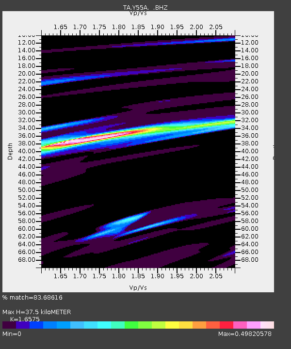
| Estimated Moho Depth: |
37.5 km |
| Estimated Crust Vp/Vs: |
1.66 |
| Assumed Crust Vp: |
6.565 km/s |
| Estimated Crust Vs: |
3.96 km/s |
| Estimated Crust Poisson's Ratio: |
0.21 |
|
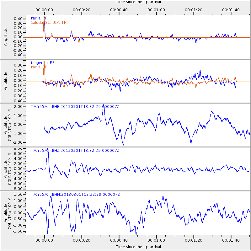
| Radial Match: |
83.68616 % |
| Radial Bump: |
347 |
| Transverse Match: |
53.424088 % |
| Transverse Bump: |
400 |
| SOD ConfigId: |
494114 |
| Insert Time: |
2013-05-15 07:39:07.719 +0000 |
| GWidth: |
2.5 |
| Max Bumps: |
400 |
| Tol: |
0.001 |
|
Signal To Noise
| Channel | StoN | STA | LTA |
| TA:Y55A: :BHZ:20130301T13:32:29.000007Z | 12.243664 | 3.4671143E-6 | 2.831762E-7 |
| TA:Y55A: :BHN:20130301T13:32:29.000007Z | 3.736506 | 8.4573134E-7 | 2.2634283E-7 |
| TA:Y55A: :BHE:20130301T13:32:29.000007Z | 3.5883818 | 1.1734708E-6 | 3.270195E-7 |
| Arrivals |
| Ps | 3.9 SECOND |
| PpPs | 15 SECOND |
| PsPs/PpSs | 19 SECOND |


